Xingtan geodata
Xingtan (Guangdong) is a seat of a fourth-order administrative division; located in China in Asia/Shanghai (GMT+8) time zone. In our database, there are 1268 cities with bigger population. Compared to other cities in China, 95.4% of cities are located further ↑North; 56.7% of cities are located further →East and 94.3% of cities have higher elevation than Xingtan. Note1


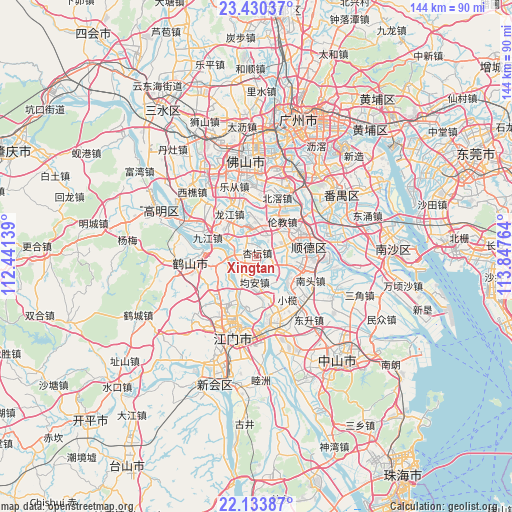
Xingtan GPS coordinates[2]
22° 47' 1.176" North, 113° 8' 40.236" East
| Map corner | latitude | longitude |
|---|---|---|
| Upper-left | 23.43037°, | 112.44139° |
| Center: | 22.78366°, | 113.14451° |
| Lower-right: | 22.13387°, | 113.84764° |
| Map W x H: | 144.2×144.2 km | = 89.6×89.6mi |
| max Lat: | 53.31946° ⇑95.4% North |
| Xingtan: | 22.78366° |
| min Lat: | ⇓4.6% South 18.22056° |
| min Long | Xingtan | max Long |
| 75.07348° | 113.14451° | 134.28917° |
| W 43.3%⇐ | ⇒56.7% E |
Elevation
Elevation of Xingtan is 7 m = 23 ft, and this is 477.8 m = 1568 ft below average elevation for this country.
| Max E: |
5622 m = 18445 ft | 94.3% |
| Avg. | 484.8 m = 1591 ft | |
| Xingtan | 7 m = 23 ft | |
Min E: |
-3 m = -10 ft | 5.7% |
See also: China elevation on elevation.city.
Geographical zone
Xingtan is located in North Torrid zone (between Equator and Tropic of Cancer). Distance of this Northern Tropic circle is 72.6 km =45.1 mi to North.| Distance of | km | miles | from Xingtan |
|---|---|---|---|
| North Pole | 7473.8 | 4644 | to North |
| Arctic Circle | 4867.9 | 3024.8 | to North |
| Tropic Cancer | 72.6 | 45.1 | to North |
| Equator | 2533.3 | 1574.1 | to South |


Nearby cities:
15 places around Xingtan: (largest is in red/bold)
• Beijiao
16.9 km =10.5 mi,  19°
19°
• Daliang
12.6 km =7.8 mi,  59°
59°
• Dongfeng
14.7 km =9.1 mi,  135°
135°
• Hetang
14.3 km =8.9 mi,  186°
186°
• Jiujiang
15.3 km =9.5 mi,  292°
292°
• Jun’an
8.7 km =5.4 mi,  178°
178°
• Leliu
8.9 km =5.5 mi,  342°
342°
• Longjiang
13.9 km =8.6 mi,  325°
325°
• Lunjiao
12.2 km =7.6 mi,  34°
34°
• Nantou
16.7 km =10.4 mi,  114°
114°
• Ronggui
11.2 km =7 mi,  102°
102°
• Shunde
15.2 km =9.4 mi,  82°
82°
• Tangxia
16.1 km =10 mi,  225°
225°
• Xiaolan
14.7 km =9.1 mi, 142°
• Yayao
16.3 km =10.1 mi,  240°
240°
Sources, notices
• [Note1] Compared only with cities in China existing in our database
• [Src1] Map data: © OpenStreetMap contributors (CC-BY-SA)
• [Src2] Other city data from geonames.org with taken over terms of usage.
• [Src3] Geographical zone / Annual Mean Temperature by Robert A. Rohde @ Wikipedia
