Tangxia geodata
Tangxia (Guangdong) is a seat of a fourth-order administrative division; located in China in Asia/Shanghai (GMT+8) time zone. In our database, there are 1268 cities with bigger population. Compared to other cities in China, 95.8% of cities are located further ↑North; 57.4% of cities are located further →East and 87.7% of cities have higher elevation than Tangxia. Note1


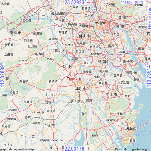
Tangxia GPS coordinates[2]
22° 40' 55.308" North, 113° 1' 55.236" East
| Map corner | latitude | longitude |
|---|---|---|
| Upper-left | 23.32923°, | 112.32889° |
| Center: | 22.68203°, | 113.03201° |
| Lower-right: | 22.03176°, | 113.73514° |
| Map W x H: | 144.3×144.3 km | = 89.7×89.7mi |
| max Lat: | 53.31946° ⇑95.8% North |
| Tangxia: | 22.68203° |
| min Lat: | ⇓4.2% South 18.22056° |
| min Long | Tangxia | max Long |
| 75.07348° | 113.03201° | 134.28917° |
| W 42.6%⇐ | ⇒57.4% E |
Elevation
Elevation of Tangxia is 12 m = 39 ft, and this is 472.8 m = 1551 ft below average elevation for this country.
| Max E: |
5622 m = 18445 ft | 87.7% |
| Avg. | 484.8 m = 1591 ft | |
| Tangxia | 12 m = 39 ft | |
Min E: |
-3 m = -10 ft | 12.3% |
See also: China elevation on elevation.city.
Geographical zone
Tangxia is located in North Torrid zone (between Equator and Tropic of Cancer). Distance of this Northern Tropic circle is 83.9 km =52.1 mi to North.| Distance of | km | miles | from Tangxia |
|---|---|---|---|
| North Pole | 7485.1 | 4651 | to North |
| Arctic Circle | 4879.2 | 3031.8 | to North |
| Tropic Cancer | 83.9 | 52.1 | to North |
| Equator | 2522 | 1567.1 | to South |


Nearby cities:
15 places around Tangxia: (largest is in red/bold)
• Baisha
12.5 km =7.8 mi,  160°
160°
• Beijie
10.7 km =6.6 mi,  138°
138°
• Canghou
10.7 km =6.6 mi, 160°
• Chaolian
9.7 km =6 mi,  124°
124°
• Duruan
8.8 km =5.5 mi,  195°
195°
• Hetang
10.3 km =6.4 mi,  106°
106°
• Huanshi
10.5 km =6.5 mi, 160°
• Jiangmen
12.2 km =7.6 mi,  154°
154°
• Jiangnan
12.1 km =7.5 mi, 146°
• Jiaobei
12 km =7.5 mi, 142°
• Jun’an
12.1 km =7.5 mi,  77°
77°
• Lianjiang
11.2 km =7 mi, 155°
• Shaping
12.4 km =7.7 mi,  322°
322°
• Tidong
11.4 km =7.1 mi, 147°
• Yayao
4.2 km =2.6 mi, 320°
Sources, notices
• [Note1] Compared only with cities in China existing in our database
• [Src1] Map data: © OpenStreetMap contributors (CC-BY-SA)
• [Src2] Other city data from geonames.org with taken over terms of usage.
• [Src3] Geographical zone / Annual Mean Temperature by Robert A. Rohde @ Wikipedia
