Xinfeng geodata
Xinfeng (Jiangsu) is a seat of a fourth-order administrative division; located in China in Asia/Shanghai (GMT+8) time zone. In our database, there are 1268 cities with bigger population. Compared to other cities in China, 61.9% of cities are located further ↓South; 79.2% of cities are located further ←West and 89.9% of cities have higher elevation than Xinfeng. Note1


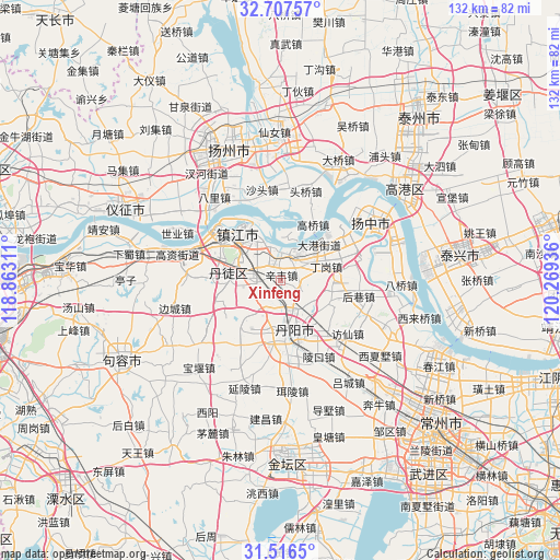
Xinfeng GPS coordinates[2]
32° 6' 50.328" North, 119° 33' 58.428" East
| Map corner | latitude | longitude |
|---|---|---|
| Upper-left | 32.70757°, | 118.86311° |
| Center: | 32.11398°, | 119.56623° |
| Lower-right: | 31.5165°, | 120.26936° |
| Map W x H: | 132.4×132.4 km | = 82.3×82.3mi |
| max Lat: | 53.31946° ⇑38.1% North |
| Xinfeng: | 32.11398° |
| min Lat: | ⇓61.9% South 18.22056° |
| min Long | Xinfeng | max Long |
| 75.07348° | 119.56623° | 134.28917° |
| W 79.2%⇐ | ⇒20.8% E |
Elevation
Elevation of Xinfeng is 10 m = 33 ft, and this is 474.8 m = 1558 ft below average elevation for this country.
| Max E: |
5622 m = 18445 ft | 89.9% |
| Avg. | 484.8 m = 1591 ft | |
| Xinfeng | 10 m = 33 ft | |
Min E: |
-3 m = -10 ft | 10.1% |
See also: China elevation on elevation.city.
Geographical zone
Xinfeng is located in North temperate zone (between Tropic of Cancer and the Arctic Circle). Distance of this Northern Tropic circle is 964.8 km =599.5 mi to South.| Distance of | km | miles | from Xinfeng |
|---|---|---|---|
| North Pole | 6436.3 | 3999.3 | to North |
| Arctic Circle | 3830.4 | 2380.1 | to North |
| Tropic Cancer | 964.8 | 599.5 | to South |
| Equator | 3570.7 | 2218.7 | to South |


Nearby cities:
15 places around Xinfeng: (largest is in red/bold)
• Dagang
12.1 km =7.5 mi,  43°
43°
• Dinggang
11.7 km =7.3 mi,  73°
73°
• Gaoqiao
15 km =9.3 mi,  31°
31°
• Guyang
11.9 km =7.4 mi,  281°
281°
• Guyang
12 km =7.5 mi,  265°
265°
• Houxiang
18.5 km =11.5 mi,  93°
93°
• Jiangqiao
11.2 km =7 mi,  296°
296°
• Picheng
13 km =8.1 mi, 87°
• Qilidian
17.3 km =10.7 mi, 295°
• Shangdang
15.5 km =9.6 mi,  253°
253°
• Situ
13.8 km =8.6 mi,  206°
206°
• Xiangshan
9.6 km =6 mi,  338°
338°
• Yunyang
13.2 km =8.2 mi,  180°
180°
• Zhengdonglu
12.6 km =7.8 mi,  314°
314°
• Zhenjiang
15 km =9.3 mi,  315°
315°
Sources, notices
• [Note1] Compared only with cities in China existing in our database
• [Src1] Map data: © OpenStreetMap contributors (CC-BY-SA)
• [Src2] Other city data from geonames.org with taken over terms of usage.
• [Src3] Geographical zone / Annual Mean Temperature by Robert A. Rohde @ Wikipedia
