Zhenjiang geodata
Zhenjiang (Jiangsu) is a seat of a second-order administrative division; located in China in Asia/Shanghai (GMT+8) time zone. With population of 632,552 people, there are 100 cities with bigger population in this country. Compared to other cities in China, 62.5% of cities are located further ↓South; 78.5% of cities are located further ←West and 80.2% of cities have higher elevation than Zhenjiang. Note1


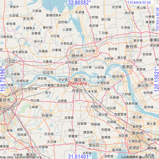
Zhenjiang GPS coordinates[2]
32° 12' 39.096" North, 119° 27' 18.288" East
| Map corner | latitude | longitude |
|---|---|---|
| Upper-left | 32.80382°, | 118.75196° |
| Center: | 32.21086°, | 119.45508° |
| Lower-right: | 31.61401°, | 120.15821° |
| Map W x H: | 132.3×132.3 km | = 82.2×82.2mi |
| max Lat: | 53.31946° ⇑37.5% North |
| Zhenjiang: | 32.21086° |
| min Lat: | ⇓62.5% South 18.22056° |
| min Long | Zhenjiang | max Long |
| 75.07348° | 119.45508° | 134.28917° |
| W 78.5%⇐ | ⇒21.5% E |
Elevation
Elevation of Zhenjiang is 26 m = 85 ft, and this is 458.8 m = 1505 ft below average elevation for this country.
| Max E: |
5622 m = 18445 ft | 80.2% |
| Avg. | 484.8 m = 1591 ft | |
| Zhenjiang | 26 m = 85 ft | |
Min E: |
-3 m = -10 ft | 19.8% |
See also: Zhenjiang elevation on elevation.city.
Geographical zone
Zhenjiang is located in North temperate zone (between Tropic of Cancer and the Arctic Circle). Distance of this Northern Tropic circle is 975.6 km =606.2 mi to South.| Distance of | km | miles | from Zhenjiang |
|---|---|---|---|
| North Pole | 6425.6 | 3992.7 | to North |
| Arctic Circle | 3819.7 | 2373.5 | to North |
| Tropic Cancer | 975.6 | 606.2 | to South |
| Equator | 3581.5 | 2225.4 | to South |


Nearby cities:
15 places around Zhenjiang: (largest is in red/bold)
• Bali
10.3 km =6.4 mi,  329°
329°
• Chahe
15.8 km =9.8 mi, 334°
• Gaozi
15.1 km =9.4 mi,  252°
252°
• Guazhou
8.3 km =5.2 mi,  304°
304°
• Guyang
8.5 km =5.3 mi,  188°
188°
• Guyang
11.8 km =7.3 mi, 187°
• Jiangqiao
5.8 km =3.6 mi,  175°
175°
• Qilidian
6 km =3.7 mi,  237°
237°
• Shangdang
15.9 km =9.9 mi,  195°
195°
• Shatou
12.6 km =7.8 mi,  29°
29°
• Shiqiao
11.3 km =7 mi,  0°
0°
• Shiye
14.3 km =8.9 mi,  271°
271°
• Xiangshan
7.2 km =4.5 mi,  104°
104°
• Xinfeng
15 km =9.3 mi,  135°
135°
• Zhengdonglu
2.5 km =1.6 mi, 144°
Sources, notices
• [Note1] Compared only with cities in China existing in our database
• [Src1] Map data: © OpenStreetMap contributors (CC-BY-SA)
• [Src2] Other city data from geonames.org with taken over terms of usage.
• [Src3] Geographical zone / Annual Mean Temperature by Robert A. Rohde @ Wikipedia
