Xin’an geodata
Xin’an (Hunan) is a seat of a fourth-order administrative division; located in China in Asia/Shanghai (GMT+8) time zone. In our database, there are 1268 cities with bigger population. Compared to other cities in China, 58% of cities are located further ↑North; 65% of cities are located further →East and 69.5% of cities have higher elevation than Xin’an. Note1


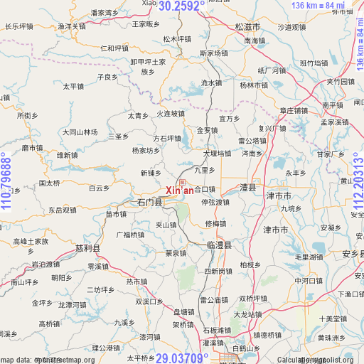
Xin’an GPS coordinates[2]
29° 39' 0" North, 111° 30' 0" East
| Map corner | latitude | longitude |
|---|---|---|
| Upper-left | 30.2592°, | 110.79688° |
| Center: | 29.65°, | 111.5° |
| Lower-right: | 29.03709°, | 112.20313° |
| Map W x H: | 135.9×135.9 km | = 84.4×84.4mi |
| max Lat: | 53.31946° ⇑58% North |
| Xin’an: | 29.65° |
| min Lat: | ⇓42% South 18.22056° |
| min Long | Xin’an | max Long |
| 75.07348° | 111.5° | 134.28917° |
| W 35%⇐ | ⇒65% E |
Elevation
Elevation of Xin’an is 54 m = 177 ft, and this is 430.8 m = 1413 ft below average elevation for this country.
| Max E: |
5622 m = 18445 ft | 69.5% |
| Avg. | 484.8 m = 1591 ft | |
| Xin’an | 54 m = 177 ft | |
Min E: |
-3 m = -10 ft | 30.5% |
See also: China elevation on elevation.city.
Geographical zone
Xin’an is located in North temperate zone (between Tropic of Cancer and the Arctic Circle). Distance of this Northern Tropic circle is 690.9 km =429.3 mi to South.| Distance of | km | miles | from Xin’an |
|---|---|---|---|
| North Pole | 6710.3 | 4169.6 | to North |
| Arctic Circle | 4104.4 | 2550.4 | to North |
| Tropic Cancer | 690.9 | 429.3 | to South |
| Equator | 3296.8 | 2048.5 | to South |


Nearby cities:
15 places around Xin’an: (largest is in red/bold)
• Chujiang
15.5 km =9.6 mi,  238°
238°
• Daping
13.9 km =8.6 mi,  84°
84°
• Dayandang
17 km =10.6 mi,  49°
49°
• Erdu
11.4 km =7.1 mi,  234°
234°
• Fangshiping
17.8 km =11.1 mi,  340°
340°
• Guanting
8 km =5 mi,  32°
32°
• Hekou
8 km =5 mi,  106°
106°
• Jiashan
16.7 km =10.4 mi,  200°
200°
• Jiuli
9.7 km =6 mi,  59°
59°
• Matoupu
16 km =9.9 mi,  327°
327°
• Shanban
10.6 km =6.6 mi,  166°
166°
• Tingxiandu
13.9 km =8.6 mi,  119°
119°
• Wangjiachang
12.8 km =8 mi,  15°
15°
• Xinpu
12.3 km =7.6 mi,  286°
286°
• Zhanggongmiao
15.2 km =9.4 mi, 110°
Sources, notices
• [Note1] Compared only with cities in China existing in our database
• [Src1] Map data: © OpenStreetMap contributors (CC-BY-SA)
• [Src2] Other city data from geonames.org with taken over terms of usage.
• [Src3] Geographical zone / Annual Mean Temperature by Robert A. Rohde @ Wikipedia
