Hekou geodata
Hekou (Hunan) is a seat of a fourth-order administrative division; located in China in Asia/Shanghai (GMT+8) time zone. In our database, there are 1268 cities with bigger population. Compared to other cities in China, 58.2% of cities are located further ↑North; 64.7% of cities are located further →East and 70.5% of cities have higher elevation than Hekou. Note1


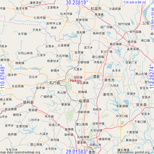
Hekou GPS coordinates[2]
29° 37' 43.896" North, 111° 34' 46.596" East
| Map corner | latitude | longitude |
|---|---|---|
| Upper-left | 30.23819°, | 110.87649° |
| Center: | 29.62886°, | 111.57961° |
| Lower-right: | 29.01583°, | 112.28274° |
| Map W x H: | 135.9×135.9 km | = 84.4×84.4mi |
| max Lat: | 53.31946° ⇑58.2% North |
| Hekou: | 29.62886° |
| min Lat: | ⇓41.8% South 18.22056° |
| min Long | Hekou | max Long |
| 75.07348° | 111.57961° | 134.28917° |
| W 35.3%⇐ | ⇒64.7% E |
Elevation
Elevation of Hekou is 50 m = 164 ft, and this is 434.8 m = 1427 ft below average elevation for this country.
| Max E: |
5622 m = 18445 ft | 70.5% |
| Avg. | 484.8 m = 1591 ft | |
| Hekou | 50 m = 164 ft | |
Min E: |
-3 m = -10 ft | 29.5% |
See also: China elevation on elevation.city.
Geographical zone
Hekou is located in North temperate zone (between Tropic of Cancer and the Arctic Circle). Distance of this Northern Tropic circle is 688.5 km =427.8 mi to South.| Distance of | km | miles | from Hekou |
|---|---|---|---|
| North Pole | 6712.6 | 4171 | to North |
| Arctic Circle | 4106.8 | 2551.8 | to North |
| Tropic Cancer | 688.5 | 427.8 | to South |
| Equator | 3294.4 | 2047 | to South |


Nearby cities:
15 places around Hekou: (largest is in red/bold)
• Chexi
14.5 km =9 mi,  47°
47°
• Daohe
17.1 km =10.6 mi,  122°
122°
• Daping
7.1 km =4.4 mi,  59°
59°
• Dayandang
14.4 km =8.9 mi,  21°
21°
• Guanting
9.7 km =6 mi,  339°
339°
• Jiuli
7.3 km =4.5 mi,  4°
4°
• Liyang
16.9 km =10.5 mi,  81°
81°
• Li’nan
17.1 km =10.6 mi,  94°
94°
• Shanban
9.5 km =5.9 mi,  212°
212°
• Tingxiandu
6.3 km =3.9 mi,  136°
136°
• Wangjiachang
15.4 km =9.6 mi, 343°
• Xin’an
8 km =5 mi,  286°
286°
• Xiumei
13.5 km =8.4 mi,  160°
160°
• Yangban
15.4 km =9.6 mi, 135°
• Zhanggongmiao
7.1 km =4.4 mi,  114°
114°
Sources, notices
• [Note1] Compared only with cities in China existing in our database
• [Src1] Map data: © OpenStreetMap contributors (CC-BY-SA)
• [Src2] Other city data from geonames.org with taken over terms of usage.
• [Src3] Geographical zone / Annual Mean Temperature by Robert A. Rohde @ Wikipedia
