Fangshiping geodata
Fangshiping (Hunan) is a seat of a fourth-order administrative division; located in China in Asia/Shanghai (GMT+8) time zone. In our database, there are 1268 cities with bigger population. Compared to other cities in China, 56.3% of cities are located further ↑North; 65.3% of cities are located further →East and 60.4% of cities have higher elevation than Fangshiping. Note1


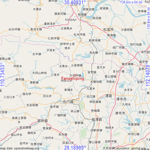
Fangshiping GPS coordinates[2]
29° 48' 3.744" North, 111° 26' 15.54" East
| Map corner | latitude | longitude |
|---|---|---|
| Upper-left | 30.40931°, | 110.73453° |
| Center: | 29.80104°, | 111.43765° |
| Lower-right: | 29.18905°, | 112.14078° |
| Map W x H: | 135.7×135.7 km | = 84.3×84.3mi |
| max Lat: | 53.31946° ⇑56.3% North |
| Fangshiping: | 29.80104° |
| min Lat: | ⇓43.7% South 18.22056° |
| min Long | Fangshiping | max Long |
| 75.07348° | 111.43765° | 134.28917° |
| W 34.7%⇐ | ⇒65.3% E |
Elevation
Elevation of Fangshiping is 96 m = 315 ft, and this is 388.8 m = 1276 ft below average elevation for this country.
| Max E: |
5622 m = 18445 ft | 60.4% |
| Avg. | 484.8 m = 1591 ft | |
| Fangshiping | 96 m = 315 ft | |
Min E: |
-3 m = -10 ft | 39.6% |
See also: China elevation on elevation.city.
Geographical zone
Fangshiping is located in North temperate zone (between Tropic of Cancer and the Arctic Circle). Distance of this Northern Tropic circle is 707.6 km =439.7 mi to South.| Distance of | km | miles | from Fangshiping |
|---|---|---|---|
| North Pole | 6693.5 | 4159.1 | to North |
| Arctic Circle | 4087.6 | 2539.9 | to North |
| Tropic Cancer | 707.6 | 439.7 | to South |
| Equator | 3313.6 | 2059 | to South |


Nearby cities:
15 places around Fangshiping: (largest is in red/bold)
• Dayandang
19.7 km =12.2 mi,  106°
106°
• Dongshi
6.1 km =3.8 mi,  278°
278°
• Ganxitan
9.5 km =5.9 mi,  321°
321°
• Guanting
14.4 km =8.9 mi,  134°
134°
• Huolianpo
9.3 km =5.8 mi,  9°
9°
• Jinluo
15.5 km =9.6 mi,  86°
86°
• Jiuli
18.6 km =11.6 mi, 129°
• Matoupu
4.2 km =2.6 mi,  217°
217°
• Sansheng
18.4 km =11.4 mi,  272°
272°
• Taiqing
14.6 km =9.1 mi,  304°
304°
• Wangjiachang
10.3 km =6.4 mi,  115°
115°
• Xinpu
14.5 km =9 mi,  203°
203°
• Xin’an
17.8 km =11.1 mi,  160°
160°
• Yangjiafang
9.2 km =5.7 mi,  236°
236°
• Zhakou
8.3 km =5.2 mi,  47°
47°
Sources, notices
• [Note1] Compared only with cities in China existing in our database
• [Src1] Map data: © OpenStreetMap contributors (CC-BY-SA)
• [Src2] Other city data from geonames.org with taken over terms of usage.
• [Src3] Geographical zone / Annual Mean Temperature by Robert A. Rohde @ Wikipedia
