Xieji geodata
Xieji (Guangdong) is a seat of a fourth-order administrative division; located in China in Asia/Urumqi (GMT+6) time zone. In our database, there are 1268 cities with bigger population. Compared to other cities in China, 97.4% of cities are located further ↑North; 67% of cities are located further →East and 65.2% of cities have higher elevation than Xieji. Note1


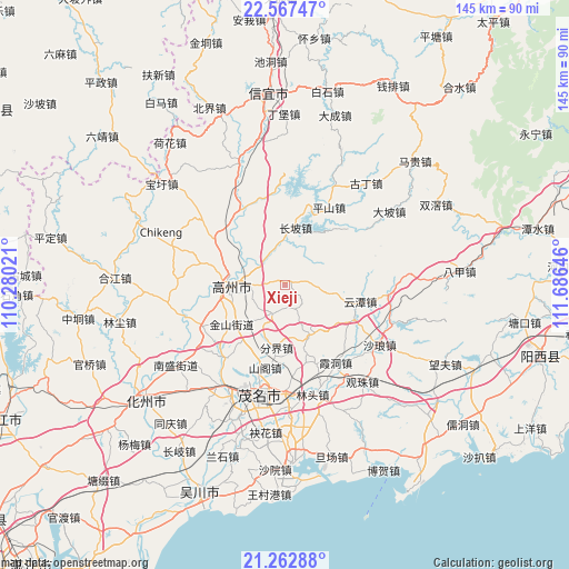
Xieji GPS coordinates[2]
21° 55' 0.012" North, 110° 58' 59.988" East
| Map corner | latitude | longitude |
|---|---|---|
| Upper-left | 22.56747°, | 110.28021° |
| Center: | 21.91667°, | 110.98333° |
| Lower-right: | 21.26288°, | 111.68646° |
| Map W x H: | 145.1×145.1 km | = 90.2×90.2mi |
| max Lat: | 53.31946° ⇑97.4% North |
| Xieji: | 21.91667° |
| min Lat: | ⇓2.6% South 18.22056° |
| min Long | Xieji | max Long |
| 75.07348° | 110.98333° | 134.28917° |
| W 33%⇐ | ⇒67% E |
Elevation
Elevation of Xieji is 72 m = 236 ft, and this is 412.8 m = 1354 ft below average elevation for this country.
| Max E: |
5622 m = 18445 ft | 65.2% |
| Avg. | 484.8 m = 1591 ft | |
| Xieji | 72 m = 236 ft | |
Min E: |
-3 m = -10 ft | 34.8% |
See also: China elevation on elevation.city.
Geographical zone
Xieji is located in North Torrid zone (between Equator and Tropic of Cancer). Distance of this Northern Tropic circle is 169 km =105 mi to North.| Distance of | km | miles | from Xieji |
|---|---|---|---|
| North Pole | 7570.2 | 4703.9 | to North |
| Arctic Circle | 4964.3 | 3084.7 | to North |
| Tropic Cancer | 169 | 105 | to North |
| Equator | 2436.9 | 1514.2 | to South |


Nearby cities:
15 places around Xieji: (largest is in red/bold)
• Baoguang
15 km =9.3 mi,  275°
275°
• Caojiang
8.6 km =5.3 mi,  332°
332°
• Changpo
16.8 km =10.4 mi,  11°
11°
• Fenjie
16.2 km =10.1 mi,  187°
187°
• Gaozhou
14.4 km =8.9 mi, 280°
• Genzi
14.3 km =8.9 mi,  155°
155°
• Huangling
19.9 km =12.4 mi,  117°
117°
• Jinshan
17.6 km =10.9 mi,  239°
239°
• Panzhou
13.9 km =8.6 mi,  274°
274°
• Shange
21.7 km =13.5 mi,  195°
195°
• Shanmei
11.4 km =7.1 mi, 277°
• Shiziling
16.9 km =10.5 mi,  259°
259°
• Sishui
6.9 km =4.3 mi, 198°
• Xindong
8.3 km =5.2 mi,  96°
96°
• Yuntan
19 km =11.8 mi, 100°
Sources, notices
• [Note1] Compared only with cities in China existing in our database
• [Src1] Map data: © OpenStreetMap contributors (CC-BY-SA)
• [Src2] Other city data from geonames.org with taken over terms of usage.
• [Src3] Geographical zone / Annual Mean Temperature by Robert A. Rohde @ Wikipedia
