Changpo geodata
Changpo (Guangdong) is a seat of a fourth-order administrative division; located in China in Asia/Urumqi (GMT+6) time zone. In our database, there are 1268 cities with bigger population. Compared to other cities in China, 97.2% of cities are located further ↑North; 66.9% of cities are located further →East and 52.5% of cities have lower elevation than Changpo. Note1


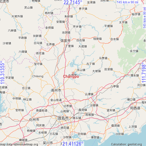
Changpo GPS coordinates[2]
22° 3' 51.768" North, 111° 1' 0.012" East
| Map corner | latitude | longitude |
|---|---|---|
| Upper-left | 22.7145°, | 110.31355° |
| Center: | 22.06438°, | 111.01667° |
| Lower-right: | 21.41126°, | 111.7198° |
| Map W x H: | 144.9×144.9 km | = 90×90mi |
| max Lat: | 53.31946° ⇑97.2% North |
| Changpo: | 22.06438° |
| min Lat: | ⇓2.8% South 18.22056° |
| min Long | Changpo | max Long |
| 75.07348° | 111.01667° | 134.28917° |
| W 33.1%⇐ | ⇒66.9% E |
Elevation
Elevation of Changpo is 184 m = 604 ft, and this is 300.8 m = 987 ft below average elevation for this country.
| Max E: |
5622 m = 18445 ft | 47.5% |
| Avg. | 484.8 m = 1591 ft | |
| Changpo | 184 m = 604 ft | |
Min E: |
-3 m = -10 ft | 52.5% |
See also: China elevation on elevation.city.
Geographical zone
Changpo is located in North Torrid zone (between Equator and Tropic of Cancer). Distance of this Northern Tropic circle is 152.6 km =94.8 mi to North.| Distance of | km | miles | from Changpo |
|---|---|---|---|
| North Pole | 7553.7 | 4693.7 | to North |
| Arctic Circle | 4947.8 | 3074.4 | to North |
| Tropic Cancer | 152.6 | 94.8 | to North |
| Equator | 2453.3 | 1524.4 | to South |


Nearby cities:
15 places around Changpo: (largest is in red/bold)
• Caojiang
11.5 km =7.1 mi,  220°
220°
• Dajing
15.1 km =9.4 mi,  278°
278°
• Dong’an
9.9 km =6.2 mi,  317°
317°
• Gaozhou
22.4 km =13.9 mi,  231°
231°
• Guding
20.9 km =13 mi,  62°
62°
• Nantang
23.5 km =14.6 mi,  269°
269°
• Panzhou
23.1 km =14.4 mi, 228°
• Pingshan
8.1 km =5 mi,  65°
65°
• Shanmei
20.9 km =13 mi, 224°
• Shenzhen
16.8 km =10.4 mi,  38°
38°
• Shuikou
23.2 km =14.4 mi,  332°
332°
• Tantou
21.2 km =13.2 mi,  309°
309°
• Xieji
16.8 km =10.4 mi,  191°
191°
• Xindong
18 km =11.2 mi,  164°
164°
• Zhenlong
22 km =13.7 mi, 318°
Sources, notices
• [Note1] Compared only with cities in China existing in our database
• [Src1] Map data: © OpenStreetMap contributors (CC-BY-SA)
• [Src2] Other city data from geonames.org with taken over terms of usage.
• [Src3] Geographical zone / Annual Mean Temperature by Robert A. Rohde @ Wikipedia
