Xieba geodata
Xieba (Guizhou) is a seat of a fourth-order administrative division; located in China in Asia/Shanghai (GMT+8) time zone. In our database, there are 1268 cities with bigger population. Compared to other cities in China, 72.3% of cities are located further ↑North; 82% of cities are located further →East and 83.9% of cities have lower elevation than Xieba. Note1


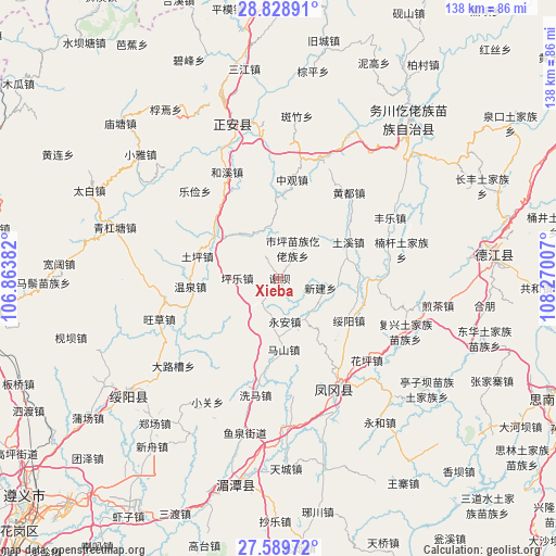
Xieba GPS coordinates[2]
28° 12' 39.996" North, 107° 34' 0.984" East
| Map corner | latitude | longitude |
|---|---|---|
| Upper-left | 28.82891°, | 106.86382° |
| Center: | 28.21111°, | 107.56694° |
| Lower-right: | 27.58972°, | 108.27007° |
| Map W x H: | 137.8×137.8 km | = 85.6×85.6mi |
| max Lat: | 53.31946° ⇑72.3% North |
| Xieba: | 28.21111° |
| min Lat: | ⇓27.7% South 18.22056° |
| min Long | Xieba | max Long |
| 75.07348° | 107.56694° | 134.28917° |
| W 18%⇐ | ⇒82% E |
Elevation
Elevation of Xieba is 912 m = 2992 ft, and this is 427.2 m = 1402 ft above average elevation for this country.
| Max E: |
5622 m = 18445 ft | 16.1% |
| Xieba | 912 m 2992 ft | |
| Avg. | 484.8 m = 1591 ft | |
Min E: |
-3 m = -10 ft | 83.9% |
See also: China elevation on elevation.city.
Geographical zone
Xieba is located in North temperate zone (between Tropic of Cancer and the Arctic Circle). Distance of this Northern Tropic circle is 530.9 km =329.9 mi to South.| Distance of | km | miles | from Xieba |
|---|---|---|---|
| North Pole | 6870.3 | 4269 | to North |
| Arctic Circle | 4264.4 | 2649.8 | to North |
| Tropic Cancer | 530.9 | 329.9 | to South |
| Equator | 3136.8 | 1949.1 | to South |


Nearby cities:
15 places around Xieba: (largest is in red/bold)
• Fuxing
24.3 km =15.1 mi,  169°
169°
• Huangdu
27.5 km =17.1 mi,  39°
39°
• Liudu
12.7 km =7.9 mi,  331°
331°
• Mashan
17.7 km =11 mi,  176°
176°
• Pingle
10.3 km =6.4 mi,  270°
270°
• Pingyuan
28.3 km =17.6 mi,  102°
102°
• Shiping
8.3 km =5.2 mi,  24°
24°
• Suiyang
20.3 km =12.6 mi,  120°
120°
• Tuping
21 km =13 mi,  286°
286°
• Tuxi
20.4 km =12.7 mi,  61°
61°
• Wenquan
21.7 km =13.5 mi, 267°
• Xihe
7.4 km =4.6 mi,  208°
208°
• Xinjian
10.6 km =6.6 mi, 102°
• Yong’an
10.8 km =6.7 mi, 172°
• Zhongguan
24.7 km =15.3 mi,  7°
7°
Sources, notices
• [Note1] Compared only with cities in China existing in our database
• [Src1] Map data: © OpenStreetMap contributors (CC-BY-SA)
• [Src2] Other city data from geonames.org with taken over terms of usage.
• [Src3] Geographical zone / Annual Mean Temperature by Robert A. Rohde @ Wikipedia
