Huangdu geodata
Huangdu (Guizhou) is a seat of a fourth-order administrative division; located in China in Asia/Shanghai (GMT+8) time zone. In our database, there are 1268 cities with bigger population. Compared to other cities in China, 70.6% of cities are located further ↑North; 81.4% of cities are located further →East and 83.2% of cities have lower elevation than Huangdu. Note1


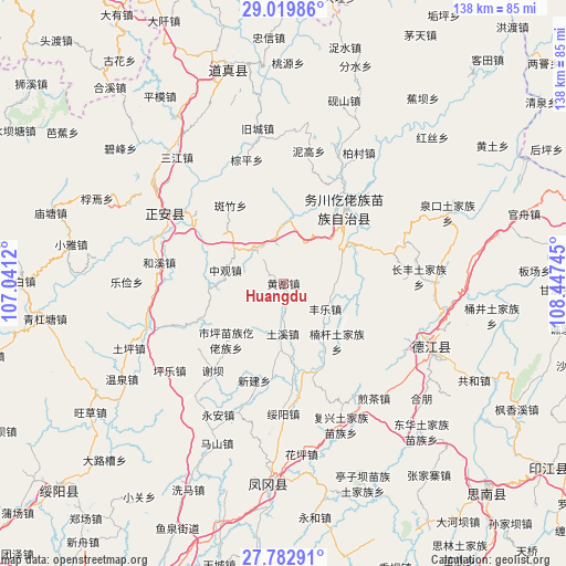
Huangdu GPS coordinates[2]
28° 24' 11.484" North, 107° 44' 39.552" East
| Map corner | latitude | longitude |
|---|---|---|
| Upper-left | 29.01986°, | 107.0412° |
| Center: | 28.40319°, | 107.74432° |
| Lower-right: | 27.78291°, | 108.44745° |
| Map W x H: | 137.5×137.5 km | = 85.4×85.4mi |
| max Lat: | 53.31946° ⇑70.6% North |
| Huangdu: | 28.40319° |
| min Lat: | ⇓29.4% South 18.22056° |
| min Long | Huangdu | max Long |
| 75.07348° | 107.74432° | 134.28917° |
| W 18.6%⇐ | ⇒81.4% E |
Elevation
Elevation of Huangdu is 864 m = 2835 ft, and this is 379.2 m = 1244 ft above average elevation for this country.
| Max E: |
5622 m = 18445 ft | 16.8% |
| Huangdu | 864 m 2835 ft | |
| Avg. | 484.8 m = 1591 ft | |
Min E: |
-3 m = -10 ft | 83.2% |
See also: China elevation on elevation.city.
Geographical zone
Huangdu is located in North temperate zone (between Tropic of Cancer and the Arctic Circle). Distance of this Northern Tropic circle is 552.2 km =343.1 mi to South.| Distance of | km | miles | from Huangdu |
|---|---|---|---|
| North Pole | 6848.9 | 4255.7 | to North |
| Arctic Circle | 4243 | 2636.5 | to North |
| Tropic Cancer | 552.2 | 343.1 | to South |
| Equator | 3158.1 | 1962.4 | to South |


Nearby cities:
15 places around Huangdu: (largest is in red/bold)
• Banzhu
23.2 km =14.4 mi,  326°
326°
• Daping
27.3 km =17 mi,  42°
42°
• Duru
19.5 km =12.1 mi,  45°
45°
• Fengle
12.2 km =7.6 mi,  119°
119°
• Fuyang
14.4 km =8.9 mi,  359°
359°
• Gelin
27.5 km =17.1 mi,  306°
306°
• Jianping
27.9 km =17.3 mi,  297°
297°
• Liudu
25.6 km =15.9 mi,  246°
246°
• Nangan
19.5 km =12.1 mi,  135°
135°
• Shaxi
25.8 km =16 mi,  111°
111°
• Shiping
19.6 km =12.2 mi,  225°
225°
• Tuxi
11.7 km =7.3 mi,  177°
177°
• Xieba
27.5 km =17.1 mi,  219°
219°
• Xinjian
24.7 km =15.3 mi,  196°
196°
• Zhongguan
14.4 km =8.9 mi,  282°
282°
Sources, notices
• [Note1] Compared only with cities in China existing in our database
• [Src1] Map data: © OpenStreetMap contributors (CC-BY-SA)
• [Src2] Other city data from geonames.org with taken over terms of usage.
• [Src3] Geographical zone / Annual Mean Temperature by Robert A. Rohde @ Wikipedia
