Wenquan geodata
Wenquan (Guizhou) is a seat of a fourth-order administrative division; located in China in Asia/Shanghai (GMT+8) time zone. In our database, there are 1268 cities with bigger population. Compared to other cities in China, 72.4% of cities are located further ↑North; 82.7% of cities are located further →East and 81.2% of cities have lower elevation than Wenquan. Note1


Wenquan GPS coordinates[2]
28° 12' 6.984" North, 107° 20' 43.008" East
| Map corner | latitude | longitude |
|---|---|---|
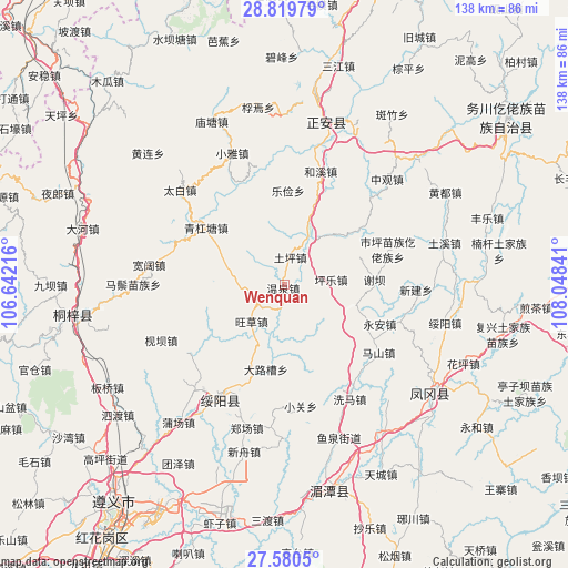
| Upper-left | 28.81979°, | 106.64216° |
| Center: | 28.20194°, | 107.34528° |
| Lower-right: | 27.5805°, | 108.04841° |
| Map W x H: | 137.8×137.8 km | = 85.6×85.6mi |
| max Lat: | 53.31946° ⇑72.4% North |
| Wenquan: | 28.20194° |
| min Lat: | ⇓27.6% South 18.22056° |
| min Long | Wenquan | max Long |
| 75.07348° | 107.34528° | 134.28917° |
| W 17.3%⇐ | ⇒82.7% E |
Elevation
Elevation of Wenquan is 751 m = 2464 ft, and this is 266.2 m = 873 ft above average elevation for this country.
| Max E: |
5622 m = 18445 ft | 18.8% |
| Wenquan | 751 m 2464 ft | |
| Avg. | 484.8 m = 1591 ft | |
Min E: |
-3 m = -10 ft | 81.2% |
See also: China elevation on elevation.city.
Geographical zone
Wenquan is located in North temperate zone (between Tropic of Cancer and the Arctic Circle). Distance of this Northern Tropic circle is 529.8 km =329.2 mi to South.| Distance of | km | miles | from Wenquan |
|---|---|---|---|
| North Pole | 6871.3 | 4269.6 | to North |
| Arctic Circle | 4265.4 | 2650.4 | to North |
| Tropic Cancer | 529.8 | 329.2 | to South |
| Equator | 3135.8 | 1948.5 | to South |


Nearby cities:
15 places around Wenquan: (largest is in red/bold)
• Dalucao
21.1 km =13.1 mi,  192°
192°
• Hexi
29.6 km =18.4 mi,  16°
16°
• Huangyang
28.5 km =17.7 mi,  291°
291°
• Lejian
22.6 km =14 mi,  2°
2°
• Liudu
19.8 km =12.3 mi,  52°
52°
• Maoya
21.4 km =13.3 mi,  235°
235°
• Mashan
28.3 km =17.6 mi,  125°
125°
• Pingle
11.5 km =7.1 mi,  84°
84°
• Shiping
26.6 km =16.5 mi,  71°
71°
• Tuping
7.2 km =4.5 mi,  12°
12°
• Wangcao
12.2 km =7.6 mi,  219°
219°
• Xieba
21.7 km =13.5 mi,  87°
87°
• Xihe
19.1 km =11.9 mi,  106°
106°
• Xinjian
32.1 km =19.9 mi, 92°
• Yong’an
25.2 km =15.7 mi, 112°
Sources, notices
• [Note1] Compared only with cities in China existing in our database
• [Src1] Map data: © OpenStreetMap contributors (CC-BY-SA)
• [Src2] Other city data from geonames.org with taken over terms of usage.
• [Src3] Geographical zone / Annual Mean Temperature by Robert A. Rohde @ Wikipedia
