Xiaolou geodata
Xiaolou (Guangdong) is a seat of a fourth-order administrative division; located in China in Asia/Shanghai (GMT+8) time zone. In our database, there are 1268 cities with bigger population. Compared to other cities in China, 92.7% of cities are located further ↑North; 52.4% of cities are located further →East and 73% of cities have higher elevation than Xiaolou. Note1


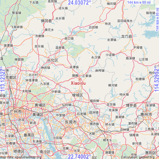
Xiaolou GPS coordinates[2]
23° 23' 12.984" North, 113° 49' 35.004" East
| Map corner | latitude | longitude |
|---|---|---|
| Upper-left | 24.03072°, | 113.12327° |
| Center: | 23.38694°, | 113.82639° |
| Lower-right: | 22.74002°, | 114.52952° |
| Map W x H: | 143.5×143.5 km | = 89.2×89.2mi |
| max Lat: | 53.31946° ⇑92.7% North |
| Xiaolou: | 23.38694° |
| min Lat: | ⇓7.3% South 18.22056° |
| min Long | Xiaolou | max Long |
| 75.07348° | 113.82639° | 134.28917° |
| W 47.6%⇐ | ⇒52.4% E |
Elevation
Elevation of Xiaolou is 42 m = 138 ft, and this is 442.8 m = 1453 ft below average elevation for this country.
| Max E: |
5622 m = 18445 ft | 73% |
| Avg. | 484.8 m = 1591 ft | |
| Xiaolou | 42 m = 138 ft | |
Min E: |
-3 m = -10 ft | 27% |
See also: China elevation on elevation.city.
Geographical zone
Xiaolou is located in North Torrid zone (between Equator and Tropic of Cancer). Distance of this Northern Tropic circle is 5.5 km =3.4 mi to North.| Distance of | km | miles | from Xiaolou |
|---|---|---|---|
| North Pole | 7406.7 | 4602.3 | to North |
| Arctic Circle | 4800.8 | 2983.1 | to North |
| Tropic Cancer | 5.5 | 3.4 | to North |
| Equator | 2600.4 | 1615.8 | to South |


Nearby cities:
15 places around Xiaolou: (largest is in red/bold)
• Changning
28.2 km =17.5 mi,  129°
129°
• Futian
23 km =14.3 mi,  145°
145°
• Jiangpu
29.3 km =18.2 mi,  306°
306°
• Licheng
10.2 km =6.3 mi,  181°
181°
• Mazha
20 km =12.4 mi,  69°
69°
• Ningxi
25.7 km =16 mi,  222°
222°
• Paitan
12.4 km =7.7 mi,  332°
332°
• Shazhuang
28.2 km =17.5 mi, 178°
• Shitan
23.9 km =14.9 mi,  189°
189°
• Shiwan
27.6 km =17.1 mi,  174°
174°
• Yonghan
25.2 km =15.7 mi,  35°
35°
• Zengjiang
8.3 km =5.2 mi,  155°
155°
• Zhengguo
7.6 km =4.7 mi, 67°
• Zhongxin
24.4 km =15.2 mi,  243°
243°
• Zhucun
18.4 km =11.4 mi,  229°
229°
Sources, notices
• [Note1] Compared only with cities in China existing in our database
• [Src1] Map data: © OpenStreetMap contributors (CC-BY-SA)
• [Src2] Other city data from geonames.org with taken over terms of usage.
• [Src3] Geographical zone / Annual Mean Temperature by Robert A. Rohde @ Wikipedia
