Mazha geodata
Mazha (Guangdong) is a seat of a fourth-order administrative division; located in China in Asia/Shanghai (GMT+8) time zone. In our database, there are 1268 cities with bigger population. Compared to other cities in China, 92.4% of cities are located further ↑North; 51.3% of cities are located further →East and 63.3% of cities have higher elevation than Mazha. Note1


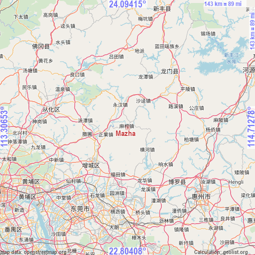
Mazha GPS coordinates[2]
23° 27' 2.484" North, 114° 0' 34.74" East
| Map corner | latitude | longitude |
|---|---|---|
| Upper-left | 24.09415°, | 113.30653° |
| Center: | 23.45069°, | 114.00965° |
| Lower-right: | 22.80408°, | 114.71278° |
| Map W x H: | 143.4×143.4 km | = 89.1×89.1mi |
| max Lat: | 53.31946° ⇑92.4% North |
| Mazha: | 23.45069° |
| min Lat: | ⇓7.6% South 18.22056° |
| min Long | Mazha | max Long |
| 75.07348° | 114.00965° | 134.28917° |
| W 48.7%⇐ | ⇒51.3% E |
Elevation
Elevation of Mazha is 81 m = 266 ft, and this is 403.8 m = 1325 ft below average elevation for this country.
| Max E: |
5622 m = 18445 ft | 63.3% |
| Avg. | 484.8 m = 1591 ft | |
| Mazha | 81 m = 266 ft | |
Min E: |
-3 m = -10 ft | 36.7% |
See also: China elevation on elevation.city.
Geographical zone
Mazha is located in North temperate zone (between Tropic of Cancer and the Arctic Circle). Distance of this Northern Tropic circle is 1.6 km =1 mi to South.| Distance of | km | miles | from Mazha |
|---|---|---|---|
| North Pole | 7399.6 | 4597.9 | to North |
| Arctic Circle | 4793.7 | 2978.7 | to North |
| Tropic Cancer | 1.6 | 1 | to South |
| Equator | 2607.5 | 1620.2 | to South |


Nearby cities:
15 places around Mazha: (largest is in red/bold)
• Changning
25.4 km =15.8 mi,  173°
173°
• Futian
26.5 km =16.5 mi,  192°
192°
• Henghe
16.2 km =10.1 mi,  137°
137°
• Huzhen
26.8 km =16.7 mi,  147°
147°
• Licheng
25.6 km =15.9 mi,  227°
227°
• Longhua
26 km =16.2 mi,  46°
46°
• Longhua
30.3 km =18.8 mi,  161°
161°
• Luxi
29.7 km =18.5 mi,  65°
65°
• Paitan
24.6 km =15.3 mi,  279°
279°
• Shajing
17.8 km =11.1 mi,  29°
29°
• Xiangshui
29.4 km =18.3 mi,  133°
133°
• Xiaolou
20 km =12.4 mi,  249°
249°
• Yonghan
13.9 km =8.6 mi,  343°
343°
• Zengjiang
21.1 km =13.1 mi, 226°
• Zhengguo
12.4 km =7.7 mi, 250°
Sources, notices
• [Note1] Compared only with cities in China existing in our database
• [Src1] Map data: © OpenStreetMap contributors (CC-BY-SA)
• [Src2] Other city data from geonames.org with taken over terms of usage.
• [Src3] Geographical zone / Annual Mean Temperature by Robert A. Rohde @ Wikipedia
