Dongfeng geodata
Dongfeng (Fujian) is a seat of a fourth-order administrative division; located in China in Asia/Shanghai (GMT+8) time zone. In our database, there are 1268 cities with bigger population. Compared to other cities in China, 78.2% of cities are located further ↑North; 73.2% of cities are located further ←West and 56.3% of cities have higher elevation than Dongfeng. Note1


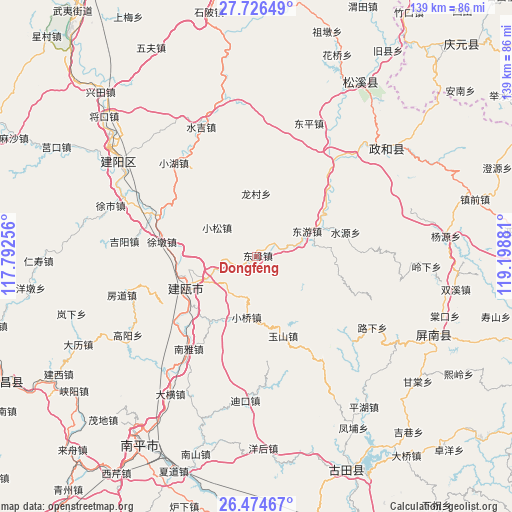
Dongfeng GPS coordinates[2]
27° 6' 8.388" North, 118° 29' 44.448" East
| Map corner | latitude | longitude |
|---|---|---|
| Upper-left | 27.72649°, | 117.79256° |
| Center: | 27.10233°, | 118.49568° |
| Lower-right: | 26.47467°, | 119.19881° |
| Map W x H: | 139.2×139.2 km | = 86.5×86.5mi |
| max Lat: | 53.31946° ⇑78.2% North |
| Dongfeng: | 27.10233° |
| min Lat: | ⇓21.8% South 18.22056° |
| min Long | Dongfeng | max Long |
| 75.07348° | 118.49568° | 134.28917° |
| W 73.2%⇐ | ⇒26.8% E |
Elevation
Elevation of Dongfeng is 122 m = 400 ft, and this is 362.8 m = 1190 ft below average elevation for this country.
| Max E: |
5622 m = 18445 ft | 56.3% |
| Avg. | 484.8 m = 1591 ft | |
| Dongfeng | 122 m = 400 ft | |
Min E: |
-3 m = -10 ft | 43.7% |
See also: China elevation on elevation.city.
Geographical zone
Dongfeng is located in North temperate zone (between Tropic of Cancer and the Arctic Circle). Distance of this Northern Tropic circle is 407.6 km =253.3 mi to South.| Distance of | km | miles | from Dongfeng |
|---|---|---|---|
| North Pole | 6993.6 | 4345.6 | to North |
| Arctic Circle | 4387.7 | 2726.4 | to North |
| Tropic Cancer | 407.6 | 253.3 | to South |
| Equator | 3013.5 | 1872.5 | to South |


Nearby cities:
15 places around Dongfeng: (largest is in red/bold)
• Chuanshi
25 km =15.5 mi,  48°
48°
• Dongyou
15 km =9.3 mi,  63°
63°
• Jian’ou
18 km =11.2 mi,  249°
249°
• Jiyang
36.3 km =22.6 mi,  276°
276°
• Longcun
16.8 km =10.4 mi,  359°
359°
• Luxia
36.3 km =22.6 mi,  121°
121°
• Nanya
31.3 km =19.4 mi,  216°
216°
• Ouning
19.9 km =12.4 mi, 246°
• Shuiyuan
25 km =15.5 mi,  75°
75°
• Shunyang
9.2 km =5.7 mi,  94°
94°
• Xiaohu
34.2 km =21.3 mi,  318°
318°
• Xiaoqiao
16.8 km =10.4 mi,  190°
190°
• Xiaosong
13.2 km =8.2 mi,  304°
304°
• Yushan
22.7 km =14.1 mi,  161°
161°
• Zhishan
18.1 km =11.2 mi, 248°
Sources, notices
• [Note1] Compared only with cities in China existing in our database
• [Src1] Map data: © OpenStreetMap contributors (CC-BY-SA)
• [Src2] Other city data from geonames.org with taken over terms of usage.
• [Src3] Geographical zone / Annual Mean Temperature by Robert A. Rohde @ Wikipedia
