Xiaochuan geodata
Xiaochuan (Gansu) is a seat of a fourth-order administrative division; located in China in Asia/Shanghai (GMT+8) time zone. In our database, there are 1268 cities with bigger population. Compared to other cities in China, 68.7% of cities are located further ↓South; 88.1% of cities are located further →East and 88.9% of cities have lower elevation than Xiaochuan. Note1


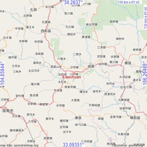
Xiaochuan GPS coordinates[2]
33° 40' 50.16" North, 105° 33' 41.616" East
| Map corner | latitude | longitude |
|---|---|---|
| Upper-left | 34.2637°, | 104.85844° |
| Center: | 33.6806°, | 105.56156° |
| Lower-right: | 33.09351°, | 106.26469° |
| Map W x H: | 130.1×130.1 km | = 80.8×80.8mi |
| max Lat: | 53.31946° ⇑31.3% North |
| Xiaochuan: | 33.6806° |
| min Lat: | ⇓68.7% South 18.22056° |
| min Long | Xiaochuan | max Long |
| 75.07348° | 105.56156° | 134.28917° |
| W 11.9%⇐ | ⇒88.1% E |
Elevation
Elevation of Xiaochuan is 1261 m = 4137 ft, and this is 776.2 m = 2547 ft above average elevation for this country.
| Max E: |
5622 m = 18445 ft | 11.1% |
| Xiaochuan | 1261 m 4137 ft | |
| Avg. | 484.8 m = 1591 ft | |
Min E: |
-3 m = -10 ft | 88.9% |
See also: China elevation on elevation.city.
Geographical zone
Xiaochuan is located in North temperate zone (between Tropic of Cancer and the Arctic Circle). Distance of this Northern Tropic circle is 1139 km =707.7 mi to South.| Distance of | km | miles | from Xiaochuan |
|---|---|---|---|
| North Pole | 6262.1 | 3891.1 | to North |
| Arctic Circle | 3656.2 | 2271.9 | to North |
| Tropic Cancer | 1139 | 707.7 | to South |
| Equator | 3744.9 | 2327 | to South |


Nearby cities:
15 places around Xiaochuan: (largest is in red/bold)
• Chengxian Chengguanzhen
17.5 km =10.9 mi,  64°
64°
• Chenyuan
14.1 km =8.8 mi,  48°
48°
• Daping
15.1 km =9.4 mi,  102°
102°
• Erlang
17.8 km =11.1 mi,  7°
7°
• Huangchen
11.5 km =7.1 mi,  161°
161°
• Huaya
8.8 km =5.5 mi,  106°
106°
• Lishan
14.6 km =9.1 mi,  177°
177°
• Liuxiang
17.1 km =10.6 mi,  320°
320°
• Paosha
11.6 km =7.2 mi,  65°
65°
• Shaba
5.6 km =3.5 mi,  2°
2°
• Suochi
5.9 km =3.7 mi,  228°
228°
• Suyuan
10.1 km =6.3 mi,  265°
265°
• Taishi
12.4 km =7.7 mi,  235°
235°
• Xigaoshan
17.1 km =10.6 mi,  290°
290°
• Zhifang
8.8 km =5.5 mi,  304°
304°
Sources, notices
• [Note1] Compared only with cities in China existing in our database
• [Src1] Map data: © OpenStreetMap contributors (CC-BY-SA)
• [Src2] Other city data from geonames.org with taken over terms of usage.
• [Src3] Geographical zone / Annual Mean Temperature by Robert A. Rohde @ Wikipedia
