Chengxian Chengguanzhen geodata
Chengxian Chengguanzhen (Gansu) is a seat of a third-order administrative division; located in China in Asia/Shanghai (GMT+8) time zone. In our database, there are 1268 cities with bigger population. Compared to other cities in China, 68.9% of cities are located further ↓South; 87.7% of cities are located further →East and 85.1% of cities have lower elevation than Chengxian Chengguanzhen. Note1
Current local time in Chengxian Chengguanzhen:
03:31 PM, TuesdayDifference from your time zone: hours


Chengxian Chengguanzhen GPS coordinates[2]
33° 44' 51.9" North, 105° 43' 58.584" East
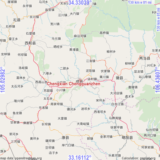
| Map corner | latitude | longitude |
|---|---|---|
| Upper-left | 34.33039°, | 105.02982° |
| Center: | 33.74775°, | 105.73294° |
| Lower-right: | 33.16112°, | 106.43607° |
| Map W x H: | 130×130 km | = 80.8×80.8mi |
| max Lat: | 53.31946° ⇑31.1% North |
| Chengxian Chengguanzhen: | 33.74775° |
| min Lat: | ⇓68.9% South 18.22056° |
| min Long | Chengxian Cheng | max Long |
| 75.07348° | 105.73294° | 134.28917° |
| W 12.3%⇐ | ⇒87.7% E |
Elevation
Elevation of Chengxian Chengguanzhen is 993 m = 3258 ft, and this is 508.2 m = 1667 ft above average elevation for this country.
| Max E: |
5622 m = 18445 ft | 14.9% |
| Chengxian Chengguanzhen | 993 m 3258 ft | |
| Avg. | 484.8 m = 1591 ft | |
Min E: |
-3 m = -10 ft | 85.1% |
See also: China elevation on elevation.city.
Geographical zone
Chengxian Chengguanzhen is located in North temperate zone (between Tropic of Cancer and the Arctic Circle). Distance of this Northern Tropic circle is 1146.5 km =712.4 mi to South.| Distance of | km | miles | from Chengxian Chengguanzhen |
|---|---|---|---|
| North Pole | 6254.7 | 3886.5 | to North |
| Arctic Circle | 3648.8 | 2267.3 | to North |
| Tropic Cancer | 1146.5 | 712.4 | to South |
| Equator | 3752.4 | 2331.6 | to South |


Nearby cities:
15 places around Chengxian Chengguanzhen: (largest is in red/bold)
• Chanba
18.5 km =11.5 mi,  172°
172°
• Chenyuan
5.6 km =3.5 mi,  289°
289°
• Daping
10.9 km =6.8 mi,  186°
186°
• Diancun
8.3 km =5.2 mi,  71°
71°
• Erlang
16.8 km =10.4 mi,  307°
307°
• Hongchuan
14.6 km =9.1 mi,  88°
88°
• Huaya
12.5 km =7.8 mi,  216°
216°
• Nankang
17.2 km =10.7 mi,  125°
125°
• Niyang
11.4 km =7.1 mi,  45°
45°
• Paosha
5.9 km =3.7 mi,  243°
243°
• Shaba
15.7 km =9.8 mi,  263°
263°
• Shuiquan
7.1 km =4.4 mi,  352°
352°
• Wangmo
12.6 km =7.8 mi,  335°
335°
• Xiaochuan
17.5 km =10.9 mi, 244°
• Zhiqi
1 km =0.6 mi,  84°
84°
Sources, notices
• [Note1] Compared only with cities in China existing in our database
• [Src1] Map data: © OpenStreetMap contributors (CC-BY-SA)
• [Src2] Other city data from geonames.org with taken over terms of usage.
• [Src3] Geographical zone / Annual Mean Temperature by Robert A. Rohde @ Wikipedia
