Xianghu geodata
Xianghu (Fujian) is a seat of a fourth-order administrative division; located in China in Asia/Shanghai (GMT+8) time zone. In our database, there are 1268 cities with bigger population. Compared to other cities in China, 84.6% of cities are located further ↑North; 69.2% of cities are located further ←West and 60.3% of cities have lower elevation than Xianghu. Note1


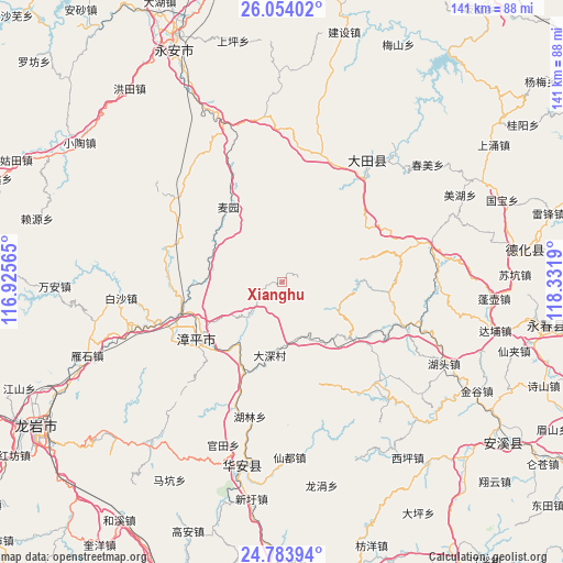
Xianghu GPS coordinates[2]
25° 25' 14.34" North, 117° 37' 43.572" East
| Map corner | latitude | longitude |
|---|---|---|
| Upper-left | 26.05402°, | 116.92565° |
| Center: | 25.42065°, | 117.62877° |
| Lower-right: | 24.78394°, | 118.3319° |
| Map W x H: | 141.2×141.2 km | = 87.7×87.7mi |
| max Lat: | 53.31946° ⇑84.6% North |
| Xianghu: | 25.42065° |
| min Lat: | ⇓15.4% South 18.22056° |
| min Long | Xianghu | max Long |
| 75.07348° | 117.62877° | 134.28917° |
| W 69.2%⇐ | ⇒30.8% E |
Elevation
Elevation of Xianghu is 263 m = 863 ft, and this is 221.8 m = 728 ft below average elevation for this country.
| Max E: |
5622 m = 18445 ft | 39.7% |
| Avg. | 484.8 m = 1591 ft | |
| Xianghu | 263 m = 863 ft | |
Min E: |
-3 m = -10 ft | 60.3% |
See also: China elevation on elevation.city.
Geographical zone
Xianghu is located in North temperate zone (between Tropic of Cancer and the Arctic Circle). Distance of this Northern Tropic circle is 220.6 km =137.1 mi to South.| Distance of | km | miles | from Xianghu |
|---|---|---|---|
| North Pole | 7180.6 | 4461.8 | to North |
| Arctic Circle | 4574.7 | 2842.6 | to North |
| Tropic Cancer | 220.6 | 137.1 | to South |
| Equator | 2826.5 | 1756.3 | to South |


Nearby cities:
15 places around Xianghu: (largest is in red/bold)
• Futian
17.4 km =10.8 mi,  185°
185°
• Gande
25.9 km =16.1 mi,  121°
121°
• Hengkou
26.6 km =16.5 mi,  81°
81°
• Heping
22.5 km =14 mi,  247°
247°
• Jingchen
26.1 km =16.2 mi,  238°
238°
• Lingdi
21.2 km =13.2 mi,  348°
348°
• Luzhi
22.9 km =14.2 mi,  227°
227°
• Taozhou
16 km =9.9 mi, 117°
• Wuci
19.7 km =12.2 mi,  4°
4°
• Wuling
25 km =15.5 mi,  20°
20°
• Xieyang
19.6 km =12.2 mi,  40°
40°
• Xinan
6 km =3.7 mi, 247°
• Xinqiao
22.7 km =14.1 mi,  327°
327°
• Yidu
18.6 km =11.6 mi, 76°
• Zhangping
25.3 km =15.7 mi, 237°
Sources, notices
• [Note1] Compared only with cities in China existing in our database
• [Src1] Map data: © OpenStreetMap contributors (CC-BY-SA)
• [Src2] Other city data from geonames.org with taken over terms of usage.
• [Src3] Geographical zone / Annual Mean Temperature by Robert A. Rohde @ Wikipedia
