Xiangyang geodata
Xiangyang (Hubei) is a seat of a second-order administrative division; located in China in Asia/Shanghai (GMT+8) time zone. With population of 462,956 people, there are 138 cities with bigger population in this country. Compared to other cities in China, 61.4% of cities are located further ↓South; 62% of cities are located further →East and 65.3% of cities have higher elevation than Xiangyang. Note1


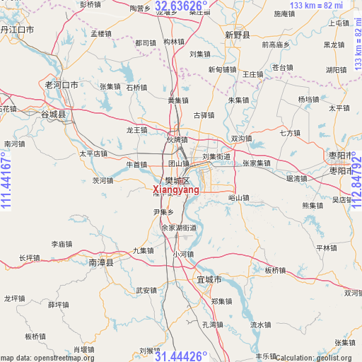
Xiangyang GPS coordinates[2]
32° 2' 31.92" North, 112° 8' 41.244" East
| Map corner | latitude | longitude |
|---|---|---|
| Upper-left | 32.63626°, | 111.44167° |
| Center: | 32.0422°, | 112.14479° |
| Lower-right: | 31.44426°, | 112.84792° |
| Map W x H: | 132.5×132.5 km | = 82.3×82.3mi |
| max Lat: | 53.31946° ⇑38.6% North |
| Xiangyang: | 32.0422° |
| min Lat: | ⇓61.4% South 18.22056° |
| min Long | Xiangyang | max Long |
| 75.07348° | 112.14479° | 134.28917° |
| W 38%⇐ | ⇒62% E |
Elevation
Elevation of Xiangyang is 71 m = 233 ft, and this is 413.8 m = 1358 ft below average elevation for this country.
| Max E: |
5622 m = 18445 ft | 65.3% |
| Avg. | 484.8 m = 1591 ft | |
| Xiangyang | 71 m = 233 ft | |
Min E: |
-3 m = -10 ft | 34.7% |
See also: Xiangyang elevation on elevation.city.
Geographical zone
Xiangyang is located in North temperate zone (between Tropic of Cancer and the Arctic Circle). Distance of this Northern Tropic circle is 956.8 km =594.5 mi to South.| Distance of | km | miles | from Xiangyang |
|---|---|---|---|
| North Pole | 6444.3 | 4004.3 | to North |
| Arctic Circle | 3838.4 | 2385.1 | to North |
| Tropic Cancer | 956.8 | 594.5 | to South |
| Equator | 3562.8 | 2213.8 | to South |


Nearby cities:
15 places around Xiangyang: (largest is in red/bold)
• Dongjin
7.8 km =4.8 mi,  103°
103°
• Huopai
13.5 km =8.4 mi,  352°
352°
• Longwang
24.9 km =15.5 mi,  319°
319°
• Longzhong
6.9 km =4.3 mi,  239°
239°
• Mizhuang
10.4 km =6.5 mi,  5°
5°
• Niushou
17.7 km =11 mi,  290°
290°
• Nizui
12.2 km =7.6 mi,  260°
260°
• Oumiao
20.2 km =12.6 mi,  173°
173°
• Shipu
6.7 km =4.2 mi,  278°
278°
• Tuanshan
6.8 km =4.2 mi, 351°
• Wangzha
2.7 km =1.7 mi,  300°
300°
• Xiangcheng
24.4 km =15.2 mi, 241°
• Yinji
13.1 km =8.1 mi,  210°
210°
• Yushan
21.8 km =13.5 mi,  105°
105°
• Zhangwan
5 km =3.1 mi,  24°
24°
Sources, notices
• [Note1] Compared only with cities in China existing in our database
• [Src1] Map data: © OpenStreetMap contributors (CC-BY-SA)
• [Src2] Other city data from geonames.org with taken over terms of usage.
• [Src3] Geographical zone / Annual Mean Temperature by Robert A. Rohde @ Wikipedia
