Xiangcheng geodata
Xiangcheng (Hubei) is a seat of a second-order administrative division; located in China in Asia/Shanghai (GMT+8) time zone. In our database, there are 1268 cities with bigger population. Compared to other cities in China, 60.8% of cities are located further ↓South; 63.1% of cities are located further →East and 56.5% of cities have lower elevation than Xiangcheng. Note1


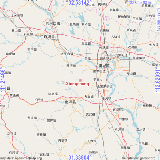
Xiangcheng GPS coordinates[2]
31° 56' 12.012" North, 111° 55' 4.008" East
| Map corner | latitude | longitude |
|---|---|---|
| Upper-left | 32.53142°, | 111.21466° |
| Center: | 31.93667°, | 111.91778° |
| Lower-right: | 31.33804°, | 112.62091° |
| Map W x H: | 132.7×132.7 km | = 82.5×82.5mi |
| max Lat: | 53.31946° ⇑39.2% North |
| Xiangcheng: | 31.93667° |
| min Lat: | ⇓60.8% South 18.22056° |
| min Long | Xiangcheng | max Long |
| 75.07348° | 111.91778° | 134.28917° |
| W 36.9%⇐ | ⇒63.1% E |
Elevation
Elevation of Xiangcheng is 221 m = 725 ft, and this is 263.8 m = 865 ft below average elevation for this country.
| Max E: |
5622 m = 18445 ft | 43.5% |
| Avg. | 484.8 m = 1591 ft | |
| Xiangcheng | 221 m = 725 ft | |
Min E: |
-3 m = -10 ft | 56.5% |
See also: China elevation on elevation.city.
Geographical zone
Xiangcheng is located in North temperate zone (between Tropic of Cancer and the Arctic Circle). Distance of this Northern Tropic circle is 945.1 km =587.3 mi to South.| Distance of | km | miles | from Xiangcheng |
|---|---|---|---|
| North Pole | 6456 | 4011.6 | to North |
| Arctic Circle | 3850.1 | 2392.3 | to North |
| Tropic Cancer | 945.1 | 587.3 | to South |
| Equator | 3551 | 2206.5 | to South |


Nearby cities:
15 places around Xiangcheng: (largest is in red/bold)
• Chengguan
18.5 km =11.5 mi,  202°
202°
• Cihe
14.6 km =9.1 mi,  328°
328°
• Limiao
25.4 km =15.8 mi,  242°
242°
• Longzhong
17.5 km =10.9 mi,  62°
62°
• Nanzhang Chengguanzhen
19 km =11.8 mi,  206°
206°
• Niushou
18.6 km =11.6 mi,  15°
15°
• Nizui
13.6 km =8.5 mi,  43°
43°
• Oumiao
25.1 km =15.6 mi,  109°
109°
• Shipu
19.4 km =12.1 mi,  49°
49°
• Taipingdian
24.6 km =15.3 mi, 333°
• Tuanshan
27.5 km =17.1 mi, 47°
• Wangzha
23.2 km =14.4 mi, 55°
• Xiangyang
24.4 km =15.2 mi, 61°
• Xiaohe
26.6 km =16.5 mi,  123°
123°
• Yinji
14.7 km =9.1 mi,  88°
88°
Sources, notices
• [Note1] Compared only with cities in China existing in our database
• [Src1] Map data: © OpenStreetMap contributors (CC-BY-SA)
• [Src2] Other city data from geonames.org with taken over terms of usage.
• [Src3] Geographical zone / Annual Mean Temperature by Robert A. Rohde @ Wikipedia
