Tuanshan geodata
Tuanshan (Hubei) is a seat of a fourth-order administrative division; located in China in Asia/Shanghai (GMT+8) time zone. In our database, there are 1268 cities with bigger population. Compared to other cities in China, 61.8% of cities are located further ↓South; 62% of cities are located further →East and 63.7% of cities have higher elevation than Tuanshan. Note1


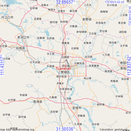
Tuanshan GPS coordinates[2]
32° 6' 10.476" North, 112° 8' 3.444" East
| Map corner | latitude | longitude |
|---|---|---|
| Upper-left | 32.69657°, | 111.43117° |
| Center: | 32.10291°, | 112.13429° |
| Lower-right: | 31.50536°, | 112.83742° |
| Map W x H: | 132.5×132.5 km | = 82.3×82.3mi |
| max Lat: | 53.31946° ⇑38.2% North |
| Tuanshan: | 32.10291° |
| min Lat: | ⇓61.8% South 18.22056° |
| min Long | Tuanshan | max Long |
| 75.07348° | 112.13429° | 134.28917° |
| W 38%⇐ | ⇒62% E |
Elevation
Elevation of Tuanshan is 79 m = 259 ft, and this is 405.8 m = 1331 ft below average elevation for this country.
| Max E: |
5622 m = 18445 ft | 63.7% |
| Avg. | 484.8 m = 1591 ft | |
| Tuanshan | 79 m = 259 ft | |
Min E: |
-3 m = -10 ft | 36.3% |
See also: China elevation on elevation.city.
Geographical zone
Tuanshan is located in North temperate zone (between Tropic of Cancer and the Arctic Circle). Distance of this Northern Tropic circle is 963.6 km =598.8 mi to South.| Distance of | km | miles | from Tuanshan |
|---|---|---|---|
| North Pole | 6437.6 | 4000.1 | to North |
| Arctic Circle | 3831.7 | 2380.9 | to North |
| Tropic Cancer | 963.6 | 598.8 | to South |
| Equator | 3569.5 | 2218 | to South |


Nearby cities:
15 places around Tuanshan: (largest is in red/bold)
• Dongjin
12.1 km =7.5 mi,  135°
135°
• Guyi
19.8 km =12.3 mi,  26°
26°
• Huangji
23.2 km =14.4 mi,  359°
359°
• Huopai
6.7 km =4.2 mi,  354°
354°
• Longwang
19.4 km =12.1 mi,  308°
308°
• Longzhong
11.4 km =7.1 mi,  205°
205°
• Mizhuang
4.1 km =2.5 mi, 28°
• Niushou
15.5 km =9.6 mi,  268°
268°
• Nizui
14 km =8.7 mi,  231°
231°
• Shipu
8.1 km =5 mi,  224°
224°
• Shuanggou
25.1 km =15.6 mi,  67°
67°
• Wangzha
5.5 km =3.4 mi,  193°
193°
• Xiangyang
6.8 km =4.2 mi,  171°
171°
• Yinji
18.9 km =11.7 mi,  197°
197°
• Zhangwan
3.8 km =2.4 mi,  125°
125°
Sources, notices
• [Note1] Compared only with cities in China existing in our database
• [Src1] Map data: © OpenStreetMap contributors (CC-BY-SA)
• [Src2] Other city data from geonames.org with taken over terms of usage.
• [Src3] Geographical zone / Annual Mean Temperature by Robert A. Rohde @ Wikipedia
