Wuzhen geodata
Wuzhen (Zhejiang) is a seat of a fourth-order administrative division; located in China in Asia/Shanghai (GMT+8) time zone. With population of 60,000 people, there are 732 cities with bigger population in this country. Compared to other cities in China, 52.5% of cities are located further ↓South; 85% of cities are located further ←West and 92.7% of cities have higher elevation than Wuzhen. Note1


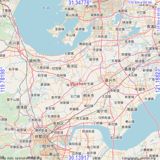
Wuzhen GPS coordinates[2]
30° 44' 43.296" North, 120° 29' 6.36" East
| Map corner | latitude | longitude |
|---|---|---|
| Upper-left | 31.34776°, | 119.78198° |
| Center: | 30.74536°, | 120.4851° |
| Lower-right: | 30.13917°, | 121.18823° |
| Map W x H: | 134.4×134.4 km | = 83.5×83.5mi |
| max Lat: | 53.31946° ⇑47.5% North |
| Wuzhen: | 30.74536° |
| min Lat: | ⇓52.5% South 18.22056° |
| min Long | Wuzhen | max Long |
| 75.07348° | 120.4851° | 134.28917° |
| W 85%⇐ | ⇒15% E |
Elevation
Elevation of Wuzhen is 8 m = 26 ft, and this is 476.8 m = 1564 ft below average elevation for this country.
| Max E: |
5622 m = 18445 ft | 92.7% |
| Avg. | 484.8 m = 1591 ft | |
| Wuzhen | 8 m = 26 ft | |
Min E: |
-3 m = -10 ft | 7.3% |
See also: Wuzhen elevation on elevation.city.
Geographical zone
Wuzhen is located in North temperate zone (between Tropic of Cancer and the Arctic Circle). Distance of this Northern Tropic circle is 812.6 km =504.9 mi to South.| Distance of | km | miles | from Wuzhen |
|---|---|---|---|
| North Pole | 6588.5 | 4093.9 | to North |
| Arctic Circle | 3982.6 | 2474.7 | to North |
| Tropic Cancer | 812.6 | 504.9 | to South |
| Equator | 3418.6 | 2124.2 | to South |


Nearby cities:
15 places around Wuzhen: (largest is in red/bold)
• Hengjingqiao
18 km =11.2 mi,  112°
112°
• Heshan
17.4 km =10.8 mi,  225°
225°
• Jiabei
22 km =13.7 mi,  80°
80°
• Lianshi
7.7 km =4.8 mi,  237°
237°
• Nanxun
15.1 km =9.4 mi,  335°
335°
• Puyuan
15.6 km =9.7 mi,  117°
117°
• Shanlian
17.8 km =11.1 mi,  252°
252°
• Shicong
21.4 km =13.3 mi,  263°
263°
• Shimen
13.7 km =8.5 mi,  197°
197°
• Shuanglin
16.8 km =10.4 mi,  283°
283°
• Taoyuan
8.2 km =5.1 mi,  6°
6°
• Tongfu
18.9 km =11.7 mi,  185°
185°
• Tongxiang
14.5 km =9 mi,  149°
149°
• Tudian
22.1 km =13.7 mi, 146°
• Zhenze
19 km =11.8 mi,  4°
4°
Sources, notices
• [Note1] Compared only with cities in China existing in our database
• [Src1] Map data: © OpenStreetMap contributors (CC-BY-SA)
• [Src2] Other city data from geonames.org with taken over terms of usage.
• [Src3] Geographical zone / Annual Mean Temperature by Robert A. Rohde @ Wikipedia
