Puyuan geodata
Puyuan (Zhejiang) is a seat of a fourth-order administrative division; located in China in Asia/Shanghai (GMT+8) time zone. In our database, there are 1268 cities with bigger population. Compared to other cities in China, 51.9% of cities are located further ↓South; 85.8% of cities are located further ←West and 86.9% of cities have higher elevation than Puyuan. Note1


Puyuan GPS coordinates[2]
30° 40' 48.792" North, 120° 37' 44.832" East
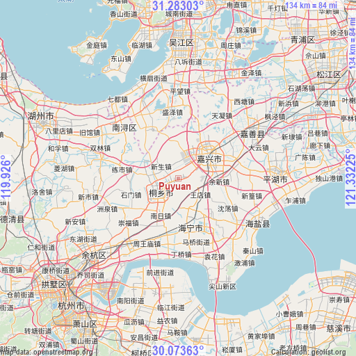
| Map corner | latitude | longitude |
|---|---|---|
| Upper-left | 31.28303°, | 119.926° |
| Center: | 30.68022°, | 120.62912° |
| Lower-right: | 30.07363°, | 121.33225° |
| Map W x H: | 134.5×134.5 km | = 83.6×83.6mi |
| max Lat: | 53.31946° ⇑48.1% North |
| Puyuan: | 30.68022° |
| min Lat: | ⇓51.9% South 18.22056° |
| min Long | Puyuan | max Long |
| 75.07348° | 120.62912° | 134.28917° |
| W 85.8%⇐ | ⇒14.2% E |
Elevation
Elevation of Puyuan is 13 m = 43 ft, and this is 471.8 m = 1548 ft below average elevation for this country.
| Max E: |
5622 m = 18445 ft | 86.9% |
| Avg. | 484.8 m = 1591 ft | |
| Puyuan | 13 m = 43 ft | |
Min E: |
-3 m = -10 ft | 13.1% |
See also: China elevation on elevation.city.
Geographical zone
Puyuan is located in North temperate zone (between Tropic of Cancer and the Arctic Circle). Distance of this Northern Tropic circle is 805.4 km =500.5 mi to South.| Distance of | km | miles | from Puyuan |
|---|---|---|---|
| North Pole | 6595.7 | 4098.4 | to North |
| Arctic Circle | 3989.9 | 2479.2 | to North |
| Tropic Cancer | 805.4 | 500.5 | to South |
| Equator | 3411.3 | 2119.7 | to South |


Nearby cities:
15 places around Puyuan: (largest is in red/bold)
• Chengnan
11.5 km =7.1 mi,  56°
56°
• Dongzha
17.5 km =10.9 mi, 59°
• Gaoqiao
19.1 km =11.9 mi,  205°
205°
• Haining
16.9 km =10.5 mi,  161°
161°
• Hengjingqiao
2.8 km =1.7 mi,  84°
84°
• Jiabei
13.6 km =8.5 mi,  35°
35°
• Jiaxing
14.1 km =8.8 mi, 55°
• Jiefang
16.8 km =10.4 mi,  49°
49°
• Shimen
18.8 km =11.7 mi,  251°
251°
• Tanghui
18.7 km =11.6 mi, 47°
• Tongxiang
8.4 km =5.2 mi,  231°
231°
• Tudian
11.2 km =7 mi,  187°
187°
• Wangdian
10.4 km =6.5 mi,  126°
126°
• Wuzhen
15.6 km =9.7 mi,  297°
297°
• Yuxin
15.3 km =9.5 mi,  94°
94°
Sources, notices
• [Note1] Compared only with cities in China existing in our database
• [Src1] Map data: © OpenStreetMap contributors (CC-BY-SA)
• [Src2] Other city data from geonames.org with taken over terms of usage.
• [Src3] Geographical zone / Annual Mean Temperature by Robert A. Rohde @ Wikipedia
