Jiabei geodata
Jiabei (Zhejiang) is a seat of a fourth-order administrative division; located in China in Asia/Shanghai (GMT+8) time zone. In our database, there are 1268 cities with bigger population. Compared to other cities in China, 52.8% of cities are located further ↓South; 86.3% of cities are located further ←West and 91.2% of cities have higher elevation than Jiabei. Note1


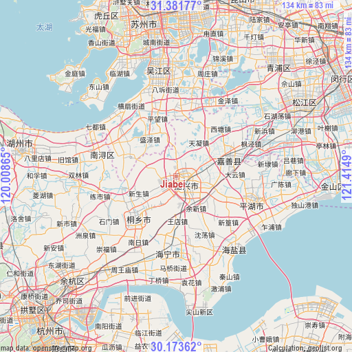
Jiabei GPS coordinates[2]
30° 46' 46.524" North, 120° 42' 42.372" East
| Map corner | latitude | longitude |
|---|---|---|
| Upper-left | 31.38177°, | 120.00865° |
| Center: | 30.77959°, | 120.71177° |
| Lower-right: | 30.17362°, | 121.4149° |
| Map W x H: | 134.3×134.3 km | = 83.5×83.5mi |
| max Lat: | 53.31946° ⇑47.2% North |
| Jiabei: | 30.77959° |
| min Lat: | ⇓52.8% South 18.22056° |
| min Long | Jiabei | max Long |
| 75.07348° | 120.71177° | 134.28917° |
| W 86.3%⇐ | ⇒13.7% E |
Elevation
Elevation of Jiabei is 9 m = 30 ft, and this is 475.8 m = 1561 ft below average elevation for this country.
| Max E: |
5622 m = 18445 ft | 91.2% |
| Avg. | 484.8 m = 1591 ft | |
| Jiabei | 9 m = 30 ft | |
Min E: |
-3 m = -10 ft | 8.8% |
See also: China elevation on elevation.city.
Geographical zone
Jiabei is located in North temperate zone (between Tropic of Cancer and the Arctic Circle). Distance of this Northern Tropic circle is 816.5 km =507.3 mi to South.| Distance of | km | miles | from Jiabei |
|---|---|---|---|
| North Pole | 6584.7 | 4091.5 | to North |
| Arctic Circle | 3978.8 | 2472.3 | to North |
| Tropic Cancer | 816.5 | 507.3 | to South |
| Equator | 3422.4 | 2126.6 | to South |


Nearby cities:
15 places around Jiabei: (largest is in red/bold)
• Chengnan
5 km =3.1 mi,  160°
160°
• Daqiao
14.3 km =8.9 mi,  104°
104°
• Dongzha
7.4 km =4.6 mi,  106°
106°
• Hengjingqiao
11.9 km =7.4 mi,  205°
205°
• Jiaxing
4.8 km =3 mi,  129°
129°
• Jiefang
4.9 km =3 mi,  91°
91°
• Puyuan
13.6 km =8.5 mi,  215°
215°
• Qixing
10.3 km =6.4 mi,  68°
68°
• Shengze
14.9 km =9.3 mi,  344°
344°
• Tanghui
6 km =3.7 mi, 73°
• Tianning
15.5 km =9.6 mi,  33°
33°
• Wangjiangjing
11.6 km =7.2 mi,  356°
356°
• Yangmiao
13.3 km =8.3 mi,  50°
50°
• Youchegang
6.5 km =4 mi, 32°
• Yuxin
14.3 km =8.9 mi,  149°
149°
Sources, notices
• [Note1] Compared only with cities in China existing in our database
• [Src1] Map data: © OpenStreetMap contributors (CC-BY-SA)
• [Src2] Other city data from geonames.org with taken over terms of usage.
• [Src3] Geographical zone / Annual Mean Temperature by Robert A. Rohde @ Wikipedia
