Taicheng geodata
Taicheng (Shanxi) is a seat of a third-order administrative division; located in China in Asia/Shanghai (GMT+8) time zone. In our database, there are 1268 cities with bigger population. Compared to other cities in China, 82.2% of cities are located further ↓South; 56.1% of cities are located further →East and 86.6% of cities have lower elevation than Taicheng. Note1


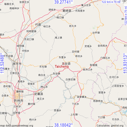
Taicheng GPS coordinates[2]
38° 43' 51.672" North, 113° 13' 40.8" East
| Map corner | latitude | longitude |
|---|---|---|
| Upper-left | 39.27741°, | 112.52488° |
| Center: | 38.73102°, | 113.228° |
| Lower-right: | 38.18042°, | 113.93113° |
| Map W x H: | 122×122 km | = 75.8×75.8mi |
| max Lat: | 53.31946° ⇑17.8% North |
| Taicheng: | 38.73102° |
| min Lat: | ⇓82.2% South 18.22056° |
| min Long | Taicheng | max Long |
| 75.07348° | 113.228° | 134.28917° |
| W 43.9%⇐ | ⇒56.1% E |
Elevation
Elevation of Taicheng is 1089 m = 3573 ft, and this is 604.2 m = 1982 ft above average elevation for this country.
| Max E: |
5622 m = 18445 ft | 13.4% |
| Taicheng | 1089 m 3573 ft | |
| Avg. | 484.8 m = 1591 ft | |
Min E: |
-3 m = -10 ft | 86.6% |
See also: China elevation on elevation.city.
Geographical zone
Taicheng is located in North temperate zone (between Tropic of Cancer and the Arctic Circle). Distance of this Northern Tropic circle is 1700.6 km =1056.7 mi to South.| Distance of | km | miles | from Taicheng |
|---|---|---|---|
| North Pole | 5700.6 | 3542.2 | to North |
| Arctic Circle | 3094.7 | 1923 | to North |
| Tropic Cancer | 1700.6 | 1056.7 | to South |
| Equator | 4306.5 | 2675.9 | to South |


Nearby cities:
15 places around Taicheng: (largest is in red/bold)
• Ekou
44.6 km =27.7 mi,  355°
355°
• Fanshi
51.1 km =31.8 mi,  3°
3°
• Jinchang
37 km =23 mi,  225°
225°
• Nieying
44.7 km =27.8 mi,  349°
349°
• Shangguan
45.6 km =28.3 mi,  325°
325°
• Shangmofang
45.4 km =28.2 mi,  336°
336°
• Tanshang
25.7 km =16 mi, 348°
• Xicun
47.7 km =29.6 mi, 348°
• Xingao
40.1 km =24.9 mi,  324°
324°
• Xingyuan
48.9 km =30.4 mi, 4°
• Yanglinjie
44.1 km =27.4 mi,  45°
45°
• Yangmingbu
43.9 km =27.3 mi, 315°
• Yantou
37.7 km =23.4 mi,  13°
13°
• Yuanping
40.9 km =25.4 mi,  267°
267°
• Yukou
39.3 km =24.4 mi, 336°
Sources, notices
• [Note1] Compared only with cities in China existing in our database
• [Src1] Map data: © OpenStreetMap contributors (CC-BY-SA)
• [Src2] Other city data from geonames.org with taken over terms of usage.
• [Src3] Geographical zone / Annual Mean Temperature by Robert A. Rohde @ Wikipedia
