Yuanping geodata
Yuanping (Shanxi) is a populated place; located in China in Asia/Shanghai (GMT+8) time zone. With population of 82,883 people, there are 513 cities with bigger population in this country. Compared to other cities in China, 82.2% of cities are located further ↓South; 58.9% of cities are located further →East and 82.1% of cities have lower elevation than Yuanping. Note1


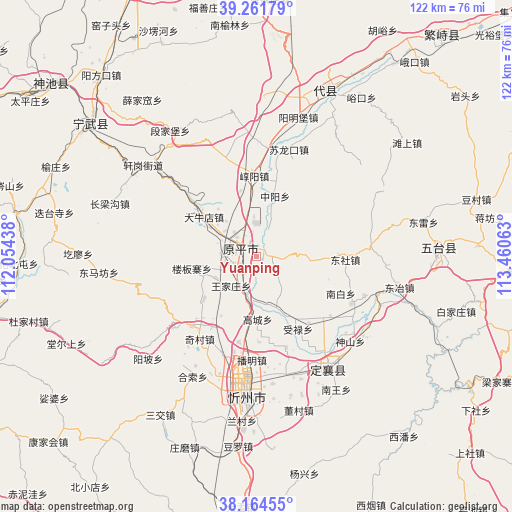
Yuanping GPS coordinates[2]
38° 42' 55.008" North, 112° 45' 27" East
| Map corner | latitude | longitude |
|---|---|---|
| Upper-left | 39.26179°, | 112.05438° |
| Center: | 38.71528°, | 112.7575° |
| Lower-right: | 38.16455°, | 113.46063° |
| Map W x H: | 122×122 km | = 75.8×75.8mi |
| max Lat: | 53.31946° ⇑17.8% North |
| Yuanping: | 38.71528° |
| min Lat: | ⇓82.2% South 18.22056° |
| min Long | Yuanping | max Long |
| 75.07348° | 112.7575° | 134.28917° |
| W 41.1%⇐ | ⇒58.9% E |
Elevation
Elevation of Yuanping is 797 m = 2615 ft, and this is 312.2 m = 1024 ft above average elevation for this country.
| Max E: |
5622 m = 18445 ft | 17.9% |
| Yuanping | 797 m 2615 ft | |
| Avg. | 484.8 m = 1591 ft | |
Min E: |
-3 m = -10 ft | 82.1% |
See also: Yuanping elevation on elevation.city.
Geographical zone
Yuanping is located in North temperate zone (between Tropic of Cancer and the Arctic Circle). Distance of this Northern Tropic circle is 1698.8 km =1055.6 mi to South.| Distance of | km | miles | from Yuanping |
|---|---|---|---|
| North Pole | 5702.3 | 3543.2 | to North |
| Arctic Circle | 3096.4 | 1924 | to North |
| Tropic Cancer | 1698.8 | 1055.6 | to South |
| Equator | 4304.7 | 2674.8 | to South |


Nearby cities:
15 places around Yuanping: (largest is in red/bold)
• Dietaisi
49.1 km =30.5 mi,  281°
281°
• Dongmafang
37.8 km =23.5 mi,  264°
264°
• Fenghuang
50.7 km =31.5 mi,  308°
308°
• Huaidao
45 km =28 mi, 264°
• Jinchang
28.1 km =17.5 mi,  149°
149°
• Shangguan
42 km =26.1 mi,  20°
20°
• Shangmofang
48.8 km =30.3 mi,  27°
27°
• Shangyuzhuang
52.4 km =32.6 mi,  294°
294°
• Taicheng
40.9 km =25.4 mi,  87°
87°
• Tanshang
44.8 km =27.8 mi,  52°
52°
• Xingao
38.8 km =24.1 mi, 27°
• Xinzhou
34.1 km =21.2 mi,  183°
183°
• Xuejiawa
46.1 km =28.6 mi,  323°
323°
• Yangmingbu
34.5 km =21.4 mi, 16°
• Yukou
45.2 km =28.1 mi, 33°
Sources, notices
• [Note1] Compared only with cities in China existing in our database
• [Src1] Map data: © OpenStreetMap contributors (CC-BY-SA)
• [Src2] Other city data from geonames.org with taken over terms of usage.
• [Src3] Geographical zone / Annual Mean Temperature by Robert A. Rohde @ Wikipedia
