Fanshi geodata
Fanshi (Shanxi) is a seat of a third-order administrative division; located in China in Asia/Shanghai (GMT+8) time zone. In our database, there are 1268 cities with bigger population. Compared to other cities in China, 83.7% of cities are located further ↓South; 55.9% of cities are located further →East and 84.2% of cities have lower elevation than Fanshi. Note1


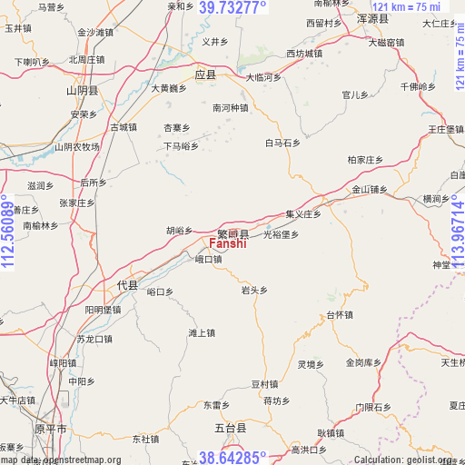
Fanshi GPS coordinates[2]
39° 11' 23.712" North, 113° 15' 50.436" East
| Map corner | latitude | longitude |
|---|---|---|
| Upper-left | 39.73277°, | 112.56089° |
| Center: | 39.18992°, | 113.26401° |
| Lower-right: | 38.64285°, | 113.96714° |
| Map W x H: | 121.2×121.2 km | = 75.3×75.3mi |
| max Lat: | 53.31946° ⇑16.3% North |
| Fanshi: | 39.18992° |
| min Lat: | ⇓83.7% South 18.22056° |
| min Long | Fanshi | max Long |
| 75.07348° | 113.26401° | 134.28917° |
| W 44.1%⇐ | ⇒55.9% E |
Elevation
Elevation of Fanshi is 925 m = 3035 ft, and this is 440.2 m = 1444 ft above average elevation for this country.
| Max E: |
5622 m = 18445 ft | 15.8% |
| Fanshi | 925 m 3035 ft | |
| Avg. | 484.8 m = 1591 ft | |
Min E: |
-3 m = -10 ft | 84.2% |
See also: China elevation on elevation.city.
Geographical zone
Fanshi is located in North temperate zone (between Tropic of Cancer and the Arctic Circle). Distance of this Northern Tropic circle is 1751.6 km =1088.4 mi to South.| Distance of | km | miles | from Fanshi |
|---|---|---|---|
| North Pole | 5649.6 | 3510.5 | to North |
| Arctic Circle | 3043.7 | 1891.3 | to North |
| Tropic Cancer | 1751.6 | 1088.4 | to South |
| Equator | 4357.5 | 2707.6 | to South |


Nearby cities:
15 places around Fanshi: (largest is in red/bold)
• Ekou
9.1 km =5.7 mi,  223°
223°
• Guangyubao
12.7 km =7.9 mi,  90°
90°
• Huyu
14 km =8.7 mi,  274°
274°
• Jiyizhuang
19.2 km =11.9 mi,  74°
74°
• Nanquan
26.7 km =16.6 mi,  343°
343°
• Nieying
13.3 km =8.3 mi,  237°
237°
• Shahe
26 km =16.2 mi, 69°
• Shangmofang
23.2 km =14.4 mi,  246°
246°
• Tanshang
27 km =16.8 mi,  197°
197°
• Xiamayu
26.5 km =16.5 mi,  329°
329°
• Xiaruyue
8.4 km =5.2 mi, 73°
• Xicun
13.5 km =8.4 mi, 251°
• Xingyuan
2.3 km =1.4 mi,  169°
169°
• Yantou
15.4 km =9.6 mi,  158°
158°
• Yukou
24.1 km =15 mi,  231°
231°
Sources, notices
• [Note1] Compared only with cities in China existing in our database
• [Src1] Map data: © OpenStreetMap contributors (CC-BY-SA)
• [Src2] Other city data from geonames.org with taken over terms of usage.
• [Src3] Geographical zone / Annual Mean Temperature by Robert A. Rohde @ Wikipedia
