Tongcheng geodata
Tongcheng (Shanxi) is a seat of a third-order administrative division; located in China in Asia/Shanghai (GMT+8) time zone. In our database, there are 1268 cities with bigger population. Compared to other cities in China, 75.7% of cities are located further ↓South; 66.2% of cities are located further →East and 72.8% of cities have lower elevation than Tongcheng. Note1


Tongcheng GPS coordinates[2]
35° 21' 16.848" North, 111° 12' 57.888" East
| Map corner | latitude | longitude |
|---|---|---|
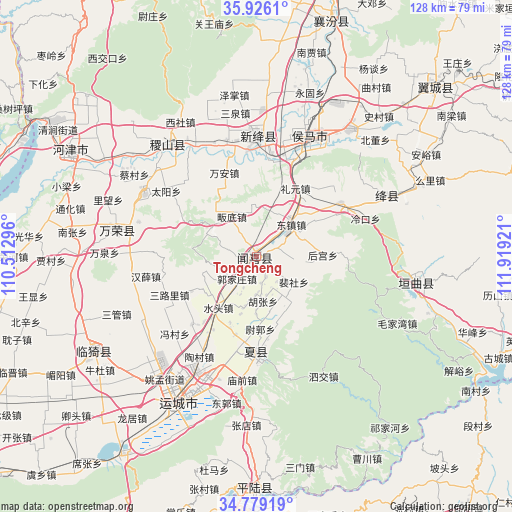
| Upper-left | 35.9261°, | 110.51296° |
| Center: | 35.35468°, | 111.21608° |
| Lower-right: | 34.77919°, | 111.91921° |
| Map W x H: | 127.5×127.5 km | = 79.2×79.2mi |
| max Lat: | 53.31946° ⇑24.3% North |
| Tongcheng: | 35.35468° |
| min Lat: | ⇓75.7% South 18.22056° |
| min Long | Tongcheng | max Long |
| 75.07348° | 111.21608° | 134.28917° |
| W 33.8%⇐ | ⇒66.2% E |
Elevation
Elevation of Tongcheng is 470 m = 1542 ft, and this is 14.8 m = 49 ft below average elevation for this country.
| Max E: |
5622 m = 18445 ft | 27.2% |
| Avg. | 484.8 m = 1591 ft | |
| Tongcheng | 470 m = 1542 ft | |
Min E: |
-3 m = -10 ft | 72.8% |
See also: China elevation on elevation.city.
Geographical zone
Tongcheng is located in North temperate zone (between Tropic of Cancer and the Arctic Circle). Distance of this Northern Tropic circle is 1325.2 km =823.4 mi to South.| Distance of | km | miles | from Tongcheng |
|---|---|---|---|
| North Pole | 6076 | 3775.5 | to North |
| Arctic Circle | 3470.1 | 2156.2 | to North |
| Tropic Cancer | 1325.2 | 823.4 | to South |
| Equator | 3931.1 | 2442.7 | to South |


Nearby cities:
15 places around Tongcheng: (largest is in red/bold)
• Guojiazhuang
7.4 km =4.6 mi,  221°
221°
• Hedi
13 km =8.1 mi,  100°
100°
• Hengqiao
24.8 km =15.4 mi,  1°
1°
• Houcun
14 km =8.7 mi,  60°
60°
• Hougong
16.5 km =10.3 mi,  88°
88°
• Liyuan
19.5 km =12.1 mi,  29°
29°
• Nanjie
11.6 km =7.2 mi,  46°
46°
• Peishe
11.3 km =7 mi,  124°
124°
• Shenbai
6.3 km =3.9 mi,  282°
282°
• Wan’an
22.3 km =13.9 mi,  339°
339°
• Xuedian
12.9 km =8 mi,  353°
353°
• Yangwang
19.3 km =12 mi,  331°
331°
• Yangyu
13.5 km =8.4 mi,  302°
302°
• Yaofeng
24 km =14.9 mi,  180°
180°
• Zhongwadi
11.4 km =7.1 mi, 329°
Sources, notices
• [Note1] Compared only with cities in China existing in our database
• [Src1] Map data: © OpenStreetMap contributors (CC-BY-SA)
• [Src2] Other city data from geonames.org with taken over terms of usage.
• [Src3] Geographical zone / Annual Mean Temperature by Robert A. Rohde @ Wikipedia
