Xuedian geodata
Xuedian (Shanxi) is a seat of a fourth-order administrative division; located in China in Asia/Shanghai (GMT+8) time zone. In our database, there are 1268 cities with bigger population. Compared to other cities in China, 75.9% of cities are located further ↓South; 66.3% of cities are located further →East and 80% of cities have lower elevation than Xuedian. Note1


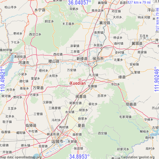
Xuedian GPS coordinates[2]
35° 28' 11.892" North, 111° 11' 57.588" East
| Map corner | latitude | longitude |
|---|---|---|
| Upper-left | 36.04057°, | 110.49621° |
| Center: | 35.46997°, | 111.19933° |
| Lower-right: | 34.8953°, | 111.90246° |
| Map W x H: | 127.3×127.3 km | = 79.1×79.1mi |
| max Lat: | 53.31946° ⇑24.1% North |
| Xuedian: | 35.46997° |
| min Lat: | ⇓75.9% South 18.22056° |
| min Long | Xuedian | max Long |
| 75.07348° | 111.19933° | 134.28917° |
| W 33.7%⇐ | ⇒66.3% E |
Elevation
Elevation of Xuedian is 697 m = 2287 ft, and this is 212.2 m = 696 ft above average elevation for this country.
| Max E: |
5622 m = 18445 ft | 20% |
| Xuedian | 697 m 2287 ft | |
| Avg. | 484.8 m = 1591 ft | |
Min E: |
-3 m = -10 ft | 80% |
See also: China elevation on elevation.city.
Geographical zone
Xuedian is located in North temperate zone (between Tropic of Cancer and the Arctic Circle). Distance of this Northern Tropic circle is 1338 km =831.4 mi to South.| Distance of | km | miles | from Xuedian |
|---|---|---|---|
| North Pole | 6063.2 | 3767.5 | to North |
| Arctic Circle | 3457.3 | 2148.3 | to North |
| Tropic Cancer | 1338 | 831.4 | to South |
| Equator | 3943.9 | 2450.6 | to South |


Nearby cities:
15 places around Xuedian: (largest is in red/bold)
• Donggaocun
16.9 km =10.5 mi,  29°
29°
• Guojiazhuang
18.7 km =11.6 mi,  190°
190°
• Hengqiao
12.2 km =7.6 mi,  10°
10°
• Houcun
15 km =9.3 mi,  113°
113°
• Liyuan
11.9 km =7.4 mi,  69°
69°
• Longxing
16 km =9.9 mi, 6°
• Nanjie
11 km =6.8 mi,  115°
115°
• Shangma
18.6 km =11.6 mi,  44°
44°
• Shangyuan
17.2 km =10.7 mi,  339°
339°
• Shenbai
12.4 km =7.7 mi,  202°
202°
• Tongcheng
12.9 km =8 mi,  173°
173°
• Wan’an
10.3 km =6.4 mi,  321°
321°
• Yangwang
8.7 km =5.4 mi,  298°
298°
• Yangyu
11.3 km =7 mi,  240°
240°
• Zhongwadi
5.2 km =3.2 mi, 235°
Sources, notices
• [Note1] Compared only with cities in China existing in our database
• [Src1] Map data: © OpenStreetMap contributors (CC-BY-SA)
• [Src2] Other city data from geonames.org with taken over terms of usage.
• [Src3] Geographical zone / Annual Mean Temperature by Robert A. Rohde @ Wikipedia
