Chang’an geodata
Chang’an (Shaanxi) is a seat of a third-order administrative division; located in China in Asia/Shanghai (GMT+8) time zone. In our database, there are 1268 cities with bigger population. Compared to other cities in China, 70.8% of cities are located further ↓South; 76.5% of cities are located further →East and 71.4% of cities have lower elevation than Chang’an. Note1


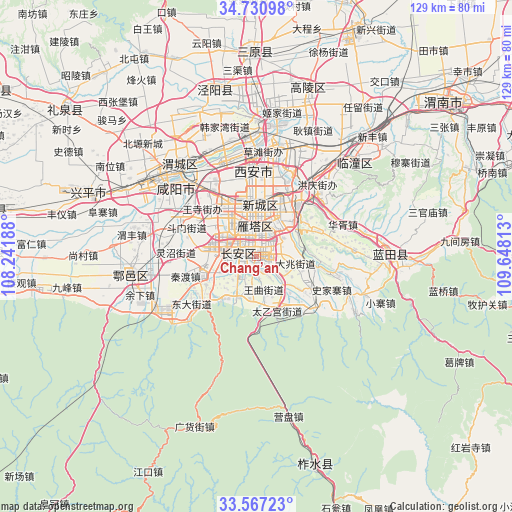
Chang’an GPS coordinates[2]
34° 9' 3.996" North, 108° 56' 42" East
| Map corner | latitude | longitude |
|---|---|---|
| Upper-left | 34.73098°, | 108.24188° |
| Center: | 34.15111°, | 108.945° |
| Lower-right: | 33.56723°, | 109.64813° |
| Map W x H: | 129.4×129.4 km | = 80.4×80.4mi |
| max Lat: | 53.31946° ⇑29.2% North |
| Chang’an: | 34.15111° |
| min Lat: | ⇓70.8% South 18.22056° |
| min Long | Chang’an | max Long |
| 75.07348° | 108.945° | 134.28917° |
| W 23.5%⇐ | ⇒76.5% E |
Elevation
Elevation of Chang’an is 439 m = 1440 ft, and this is 45.8 m = 150 ft below average elevation for this country.
| Max E: |
5622 m = 18445 ft | 28.6% |
| Avg. | 484.8 m = 1591 ft | |
| Chang’an | 439 m = 1440 ft | |
Min E: |
-3 m = -10 ft | 71.4% |
See also: China elevation on elevation.city.
Geographical zone
Chang’an is located in North temperate zone (between Tropic of Cancer and the Arctic Circle). Distance of this Northern Tropic circle is 1191.3 km =740.2 mi to South.| Distance of | km | miles | from Chang’an |
|---|---|---|---|
| North Pole | 6209.8 | 3858.6 | to North |
| Arctic Circle | 3603.9 | 2239.4 | to North |
| Tropic Cancer | 1191.3 | 740.2 | to South |
| Equator | 3797.2 | 2359.5 | to South |


Nearby cities:
15 places around Chang’an: (largest is in red/bold)
• Beilin
9 km =5.6 mi,  342°
342°
• Changyanbao
4.7 km =2.9 mi,  5°
5°
• Dengjiapo
11.2 km =7 mi,  41°
41°
• Dianzicheng
5.9 km =3.7 mi,  320°
320°
• Duqu
6.9 km =4.3 mi,  131°
131°
• Guodu
7.4 km =4.6 mi,  273°
273°
• Huangliang
7.9 km =4.9 mi,  215°
215°
• Lianhu
12.1 km =7.5 mi,  350°
350°
• Qujiang
6.1 km =3.8 mi, 40°
• Wangqu
8.4 km =5.2 mi,  168°
168°
• Xi’an
12 km =7.5 mi, 352°
• Yanta
6.2 km =3.9 mi, 6°
• Yuhuazhai
11.8 km =7.3 mi, 315°
• Zhangbagou
9.1 km =5.7 mi, 319°
• Ziwu
11.4 km =7.1 mi,  204°
204°
Sources, notices
• [Note1] Compared only with cities in China existing in our database
• [Src1] Map data: © OpenStreetMap contributors (CC-BY-SA)
• [Src2] Other city data from geonames.org with taken over terms of usage.
• [Src3] Geographical zone / Annual Mean Temperature by Robert A. Rohde @ Wikipedia
