Changyanbao geodata
Changyanbao (Shaanxi) is a seat of a fourth-order administrative division; located in China in Asia/Shanghai (GMT+8) time zone. In our database, there are 1268 cities with bigger population. Compared to other cities in China, 71% of cities are located further ↓South; 76.5% of cities are located further →East and 71.3% of cities have lower elevation than Changyanbao. Note1


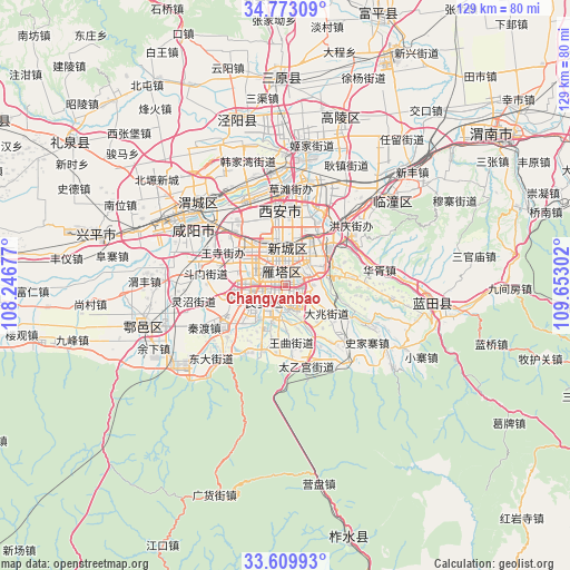
Changyanbao GPS coordinates[2]
34° 11' 36.672" North, 108° 56' 59.604" East
| Map corner | latitude | longitude |
|---|---|---|
| Upper-left | 34.77309°, | 108.24677° |
| Center: | 34.19352°, | 108.94989° |
| Lower-right: | 33.60993°, | 109.65302° |
| Map W x H: | 129.3×129.3 km | = 80.3×80.3mi |
| max Lat: | 53.31946° ⇑29% North |
| Changyanbao: | 34.19352° |
| min Lat: | ⇓71% South 18.22056° |
| min Long | Changyanbao | max Long |
| 75.07348° | 108.94989° | 134.28917° |
| W 23.5%⇐ | ⇒76.5% E |
Elevation
Elevation of Changyanbao is 437 m = 1434 ft, and this is 47.8 m = 157 ft below average elevation for this country.
| Max E: |
5622 m = 18445 ft | 28.7% |
| Avg. | 484.8 m = 1591 ft | |
| Changyanbao | 437 m = 1434 ft | |
Min E: |
-3 m = -10 ft | 71.3% |
See also: China elevation on elevation.city.
Geographical zone
Changyanbao is located in North temperate zone (between Tropic of Cancer and the Arctic Circle). Distance of this Northern Tropic circle is 1196 km =743.2 mi to South.| Distance of | km | miles | from Changyanbao |
|---|---|---|---|
| North Pole | 6205.1 | 3855.7 | to North |
| Arctic Circle | 3599.2 | 2236.4 | to North |
| Tropic Cancer | 1196 | 743.2 | to South |
| Equator | 3802 | 2362.5 | to South |


Nearby cities:
15 places around Changyanbao: (largest is in red/bold)
• Beilin
5 km =3.1 mi,  320°
320°
• Chang’an
4.7 km =2.9 mi,  185°
185°
• Dengjiapo
7.9 km =4.9 mi,  61°
61°
• Dianzicheng
4.2 km =2.6 mi,  267°
267°
• Duqu
10.4 km =6.5 mi,  152°
152°
• Guodu
8.9 km =5.5 mi,  241°
241°
• Lianhu
7.6 km =4.7 mi,  341°
341°
• Qujiang
3.5 km =2.2 mi,  90°
90°
• Weiyang
10.9 km =6.8 mi,  353°
353°
• Weiyanggong
11.3 km =7 mi, 341°
• Xincheng
7.7 km =4.8 mi,  359°
359°
• Xi’an
7.5 km =4.7 mi, 344°
• Yanta
1.4 km =0.9 mi,  9°
9°
• Yuhuazhai
9.4 km =5.8 mi,  293°
293°
• Zhangbagou
6.8 km =4.2 mi, 288°
Sources, notices
• [Note1] Compared only with cities in China existing in our database
• [Src1] Map data: © OpenStreetMap contributors (CC-BY-SA)
• [Src2] Other city data from geonames.org with taken over terms of usage.
• [Src3] Geographical zone / Annual Mean Temperature by Robert A. Rohde @ Wikipedia
