Beilin geodata
Beilin (Shaanxi) is a seat of a third-order administrative division; located in China in Asia/Shanghai (GMT+8) time zone. In our database, there are 1268 cities with bigger population. Compared to other cities in China, 71.2% of cities are located further ↓South; 76.7% of cities are located further →East and 70.1% of cities have lower elevation than Beilin. Note1


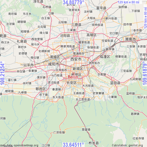
Beilin GPS coordinates[2]
34° 13' 42.456" North, 108° 54' 56.376" East
| Map corner | latitude | longitude |
|---|---|---|
| Upper-left | 34.80779°, | 108.21254° |
| Center: | 34.22846°, | 108.91566° |
| Lower-right: | 33.64511°, | 109.61879° |
| Map W x H: | 129.3×129.3 km | = 80.3×80.3mi |
| max Lat: | 53.31946° ⇑28.8% North |
| Beilin: | 34.22846° |
| min Lat: | ⇓71.2% South 18.22056° |
| min Long | Beilin | max Long |
| 75.07348° | 108.91566° | 134.28917° |
| W 23.3%⇐ | ⇒76.7% E |
Elevation
Elevation of Beilin is 414 m = 1358 ft, and this is 70.8 m = 232 ft below average elevation for this country.
| Max E: |
5622 m = 18445 ft | 29.9% |
| Avg. | 484.8 m = 1591 ft | |
| Beilin | 414 m = 1358 ft | |
Min E: |
-3 m = -10 ft | 70.1% |
See also: China elevation on elevation.city.
Geographical zone
Beilin is located in North temperate zone (between Tropic of Cancer and the Arctic Circle). Distance of this Northern Tropic circle is 1199.9 km =745.6 mi to South.| Distance of | km | miles | from Beilin |
|---|---|---|---|
| North Pole | 6201.2 | 3853.2 | to North |
| Arctic Circle | 3595.3 | 2234 | to North |
| Tropic Cancer | 1199.9 | 745.6 | to South |
| Equator | 3805.8 | 2364.8 | to South |


Nearby cities:
15 places around Beilin: (largest is in red/bold)
• Changyanbao
5 km =3.1 mi,  140°
140°
• Chang’an
9 km =5.6 mi,  162°
162°
• Daminggong
9.5 km =5.9 mi,  27°
27°
• Dianzicheng
4.2 km =2.6 mi,  194°
194°
• Guodu
9.4 km =5.8 mi,  210°
210°
• Lianhu
3.4 km =2.1 mi,  13°
13°
• Qujiang
7.7 km =4.8 mi,  120°
120°
• Sanqiao
9.8 km =6.1 mi,  311°
311°
• Weiyang
7.1 km =4.4 mi, 14°
• Weiyanggong
6.8 km =4.2 mi,  356°
356°
• Xincheng
5 km =3.1 mi,  38°
38°
• Xi’an
3.5 km =2.2 mi,  19°
19°
• Yanta
4.2 km =2.6 mi,  126°
126°
• Yuhuazhai
5.5 km =3.4 mi,  268°
268°
• Zhangbagou
3.7 km =2.3 mi,  242°
242°
Sources, notices
• [Note1] Compared only with cities in China existing in our database
• [Src1] Map data: © OpenStreetMap contributors (CC-BY-SA)
• [Src2] Other city data from geonames.org with taken over terms of usage.
• [Src3] Geographical zone / Annual Mean Temperature by Robert A. Rohde @ Wikipedia
