Wangluo geodata
Wangluo (Henan) is a seat of a fourth-order administrative division; located in China in Asia/Shanghai (GMT+8) time zone. In our database, there are 1268 cities with bigger population. Compared to other cities in China, 69.9% of cities are located further ↓South; 54.4% of cities are located further →East and 58.9% of cities have higher elevation than Wangluo. Note1


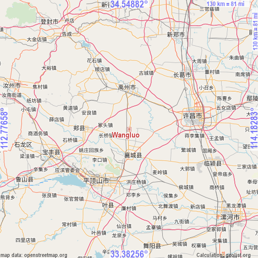
Wangluo GPS coordinates[2]
33° 58' 3.684" North, 113° 28' 46.92" East
| Map corner | latitude | longitude |
|---|---|---|
| Upper-left | 34.54882°, | 112.77658° |
| Center: | 33.96769°, | 113.4797° |
| Lower-right: | 33.38256°, | 114.18283° |
| Map W x H: | 129.7×129.7 km | = 80.6×80.6mi |
| max Lat: | 53.31946° ⇑30.1% North |
| Wangluo: | 33.96769° |
| min Lat: | ⇓69.9% South 18.22056° |
| min Long | Wangluo | max Long |
| 75.07348° | 113.4797° | 134.28917° |
| W 45.6%⇐ | ⇒54.4% E |
Elevation
Elevation of Wangluo is 105 m = 344 ft, and this is 379.8 m = 1246 ft below average elevation for this country.
| Max E: |
5622 m = 18445 ft | 58.9% |
| Avg. | 484.8 m = 1591 ft | |
| Wangluo | 105 m = 344 ft | |
Min E: |
-3 m = -10 ft | 41.1% |
See also: China elevation on elevation.city.
Geographical zone
Wangluo is located in North temperate zone (between Tropic of Cancer and the Arctic Circle). Distance of this Northern Tropic circle is 1170.9 km =727.6 mi to South.| Distance of | km | miles | from Wangluo |
|---|---|---|---|
| North Pole | 6230.2 | 3871.3 | to North |
| Arctic Circle | 3624.3 | 2252 | to North |
| Tropic Cancer | 1170.9 | 727.6 | to South |
| Equator | 3776.9 | 2346.9 | to South |


Nearby cities:
15 places around Wangluo: (largest is in red/bold)
• Changqiao
12.6 km =7.8 mi,  254°
254°
• Cigou
17.7 km =11 mi,  147°
147°
• Fenchen
4.7 km =2.9 mi,  85°
85°
• Kuzhuang
10.3 km =6.4 mi,  134°
134°
• Shantoudian
20.3 km =12.6 mi,  168°
168°
• Shenjian
19.8 km =12.3 mi,  74°
74°
• Shilipu
10.6 km =6.6 mi,  205°
205°
• Shuangmiao
15.7 km =9.8 mi,  115°
115°
• Tangjie
17.1 km =10.6 mi,  242°
242°
• Xiangcheng Chengguanzhen
13.4 km =8.3 mi,  180°
180°
• Yingqiao
9.7 km =6 mi, 92°
• Yingyang
12.3 km =7.6 mi,  98°
98°
• Zhanbei
21.4 km =13.3 mi,  188°
188°
• Zhongtou
13.1 km =8.1 mi,  280°
280°
• Ziyun
17.1 km =10.6 mi,  195°
195°
Sources, notices
• [Note1] Compared only with cities in China existing in our database
• [Src1] Map data: © OpenStreetMap contributors (CC-BY-SA)
• [Src2] Other city data from geonames.org with taken over terms of usage.
• [Src3] Geographical zone / Annual Mean Temperature by Robert A. Rohde @ Wikipedia
