Shenjian geodata
Shenjian (Henan) is a seat of a fourth-order administrative division; located in China in Asia/Shanghai (GMT+8) time zone. In our database, there are 1268 cities with bigger population. Compared to other cities in China, 70.1% of cities are located further ↓South; 53.1% of cities are located further →East and 62.4% of cities have higher elevation than Shenjian. Note1


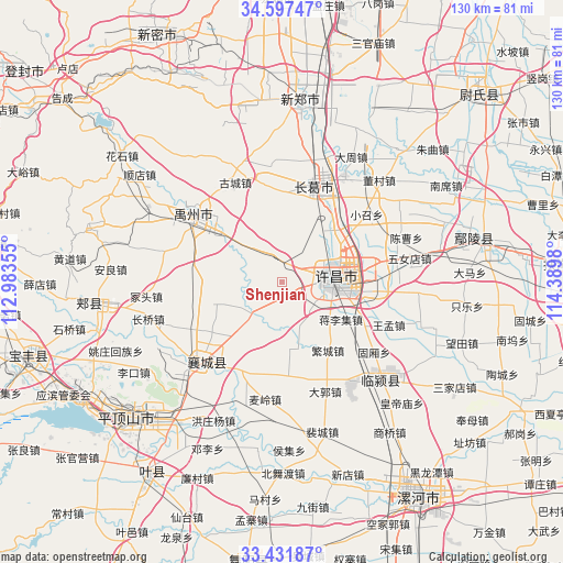
Shenjian GPS coordinates[2]
34° 1' 0.012" North, 113° 41' 12.012" East
| Map corner | latitude | longitude |
|---|---|---|
| Upper-left | 34.59747°, | 112.98355° |
| Center: | 34.01667°, | 113.68667° |
| Lower-right: | 33.43187°, | 114.3898° |
| Map W x H: | 129.6×129.6 km | = 80.5×80.5mi |
| max Lat: | 53.31946° ⇑29.9% North |
| Shenjian: | 34.01667° |
| min Lat: | ⇓70.1% South 18.22056° |
| min Long | Shenjian | max Long |
| 75.07348° | 113.68667° | 134.28917° |
| W 46.9%⇐ | ⇒53.1% E |
Elevation
Elevation of Shenjian is 85 m = 279 ft, and this is 399.8 m = 1312 ft below average elevation for this country.
| Max E: |
5622 m = 18445 ft | 62.4% |
| Avg. | 484.8 m = 1591 ft | |
| Shenjian | 85 m = 279 ft | |
Min E: |
-3 m = -10 ft | 37.6% |
See also: China elevation on elevation.city.
Geographical zone
Shenjian is located in North temperate zone (between Tropic of Cancer and the Arctic Circle). Distance of this Northern Tropic circle is 1176.4 km =731 mi to South.| Distance of | km | miles | from Shenjian |
|---|---|---|---|
| North Pole | 6224.8 | 3867.9 | to North |
| Arctic Circle | 3618.9 | 2248.7 | to North |
| Tropic Cancer | 1176.4 | 731 | to South |
| Equator | 3782.3 | 2350.2 | to South |


Nearby cities:
15 places around Shenjian: (largest is in red/bold)
• Cigou
22.6 km =14 mi,  205°
205°
• Fanhu
19.1 km =11.9 mi,  181°
181°
• Fenchen
15.3 km =9.5 mi,  250°
250°
• Jiangguanchi
16.9 km =10.5 mi,  96°
96°
• Jiangliji
16.1 km =10 mi,  121°
121°
• Jianshe
23.6 km =14.7 mi,  18°
18°
• Kuzhuang
17.3 km =10.7 mi,  222°
222°
• Shiqiao
22 km =13.7 mi, 117°
• Shuangmiao
13.1 km =8.1 mi,  201°
201°
• Wangluo
19.8 km =12.3 mi, 254°
• Wangmeng
26.6 km =16.5 mi,  111°
111°
• Xuchang
16.3 km =10.1 mi,  84°
84°
• Yingchuan
26.2 km =16.3 mi,  308°
308°
• Yingqiao
11.1 km =6.9 mi,  237°
237°
• Yingyang
10 km =6.2 mi, 223°
Sources, notices
• [Note1] Compared only with cities in China existing in our database
• [Src1] Map data: © OpenStreetMap contributors (CC-BY-SA)
• [Src2] Other city data from geonames.org with taken over terms of usage.
• [Src3] Geographical zone / Annual Mean Temperature by Robert A. Rohde @ Wikipedia
