Leiyang geodata
Leiyang (Anhui) is a seat of a third-order administrative division; located in China in Asia/Shanghai (GMT+8) time zone. In our database, there are 1268 cities with bigger population. Compared to other cities in China, 52.8% of cities are located further ↑North; 64.2% of cities are located further ←West and 85.5% of cities have higher elevation than Leiyang. Note1


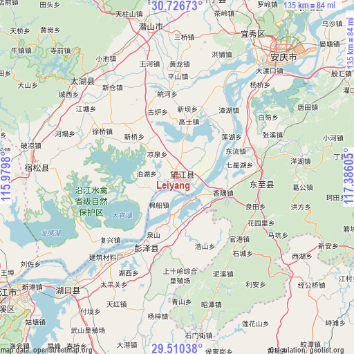
Leiyang GPS coordinates[2]
30° 7' 13.548" North, 116° 40' 58.512" East
| Map corner | latitude | longitude |
|---|---|---|
| Upper-left | 30.72673°, | 115.9798° |
| Center: | 30.12043°, | 116.68292° |
| Lower-right: | 29.51038°, | 117.38605° |
| Map W x H: | 135.2×135.2 km | = 84×84mi |
| max Lat: | 53.31946° ⇑52.8% North |
| Leiyang: | 30.12043° |
| min Lat: | ⇓47.2% South 18.22056° |
| min Long | Leiyang | max Long |
| 75.07348° | 116.68292° | 134.28917° |
| W 64.2%⇐ | ⇒35.8% E |
Elevation
Elevation of Leiyang is 15 m = 49 ft, and this is 469.8 m = 1541 ft below average elevation for this country.
| Max E: |
5622 m = 18445 ft | 85.5% |
| Avg. | 484.8 m = 1591 ft | |
| Leiyang | 15 m = 49 ft | |
Min E: |
-3 m = -10 ft | 14.5% |
See also: China elevation on elevation.city.
Geographical zone
Leiyang is located in North temperate zone (between Tropic of Cancer and the Arctic Circle). Distance of this Northern Tropic circle is 743.2 km =461.8 mi to South.| Distance of | km | miles | from Leiyang |
|---|---|---|---|
| North Pole | 6658 | 4137.1 | to North |
| Arctic Circle | 4052.1 | 2517.9 | to North |
| Tropic Cancer | 743.2 | 461.8 | to South |
| Equator | 3349.1 | 2081 | to South |


Nearby cities:
15 places around Leiyang: (largest is in red/bold)
• Dingshan
42.2 km =26.2 mi,  218°
218°
• Dongsheng
32.3 km =20.1 mi,  177°
177°
• Furongdun
34.3 km =21.3 mi,  212°
212°
• Fuxing
35.2 km =21.9 mi,  227°
227°
• Guangang
33.1 km =20.6 mi,  134°
134°
• Haoshan
28.2 km =17.5 mi,  158°
158°
• Huanghua
29.9 km =18.6 mi,  196°
196°
• Huangling
37.4 km =23.2 mi, 197°
• Huayuanli
36.3 km =22.6 mi,  118°
118°
• Longcheng
27.7 km =17.2 mi, 206°
• Madang
14.7 km =9.1 mi,  190°
190°
• Makeng
44.4 km =27.6 mi, 119°
• Nixi
40.5 km =25.2 mi,  154°
154°
• Rangxi
23.1 km =14.4 mi,  170°
170°
• Yaodu
32.2 km =20 mi,  94°
94°
Sources, notices
• [Note1] Compared only with cities in China existing in our database
• [Src1] Map data: © OpenStreetMap contributors (CC-BY-SA)
• [Src2] Other city data from geonames.org with taken over terms of usage.
• [Src3] Geographical zone / Annual Mean Temperature by Robert A. Rohde @ Wikipedia
