Dongsheng geodata
Dongsheng (Jiangxi) is a seat of a fourth-order administrative division; located in China in Asia/Shanghai (GMT+8) time zone. In our database, there are 1268 cities with bigger population. Compared to other cities in China, 56% of cities are located further ↑North; 64.3% of cities are located further ←West and 77.2% of cities have higher elevation than Dongsheng. Note1


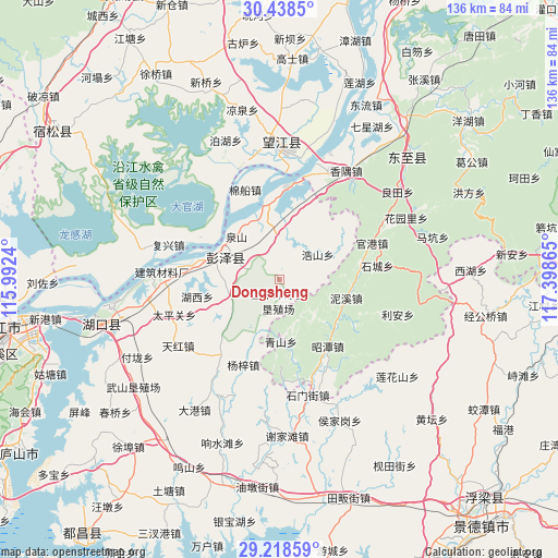
Dongsheng GPS coordinates[2]
29° 49' 49.476" North, 116° 41' 43.872" East
| Map corner | latitude | longitude |
|---|---|---|
| Upper-left | 30.4385°, | 115.9924° |
| Center: | 29.83041°, | 116.69552° |
| Lower-right: | 29.21859°, | 117.39865° |
| Map W x H: | 135.6×135.6 km | = 84.3×84.3mi |
| max Lat: | 53.31946° ⇑56% North |
| Dongsheng: | 29.83041° |
| min Lat: | ⇓44% South 18.22056° |
| min Long | Dongsheng | max Long |
| 75.07348° | 116.69552° | 134.28917° |
| W 64.3%⇐ | ⇒35.7% E |
Elevation
Elevation of Dongsheng is 32 m = 105 ft, and this is 452.8 m = 1486 ft below average elevation for this country.
| Max E: |
5622 m = 18445 ft | 77.2% |
| Avg. | 484.8 m = 1591 ft | |
| Dongsheng | 32 m = 105 ft | |
Min E: |
-3 m = -10 ft | 22.8% |
See also: China elevation on elevation.city.
Geographical zone
Dongsheng is located in North temperate zone (between Tropic of Cancer and the Arctic Circle). Distance of this Northern Tropic circle is 710.9 km =441.7 mi to South.| Distance of | km | miles | from Dongsheng |
|---|---|---|---|
| North Pole | 6690.2 | 4157.1 | to North |
| Arctic Circle | 4084.3 | 2537.9 | to North |
| Tropic Cancer | 710.9 | 441.7 | to South |
| Equator | 3316.8 | 2061 | to South |


Nearby cities:
15 places around Dongsheng: (largest is in red/bold)
• Dingshan
27.6 km =17.1 mi,  268°
268°
• Furongdun
19.8 km =12.3 mi,  279°
279°
• Guangang
24.2 km =15 mi,  68°
68°
• Haoshan
11 km =6.8 mi,  56°
56°
• Huanghua
10.4 km =6.5 mi,  290°
290°
• Huangling
13 km =8.1 mi,  254°
254°
• Longcheng
15.4 km =9.6 mi,  298°
298°
• Longquan
24 km =14.9 mi,  151°
151°
• Madang
18.3 km =11.4 mi,  347°
347°
• Nixi
16.8 km =10.4 mi,  104°
104°
• Qingshan
15.2 km =9.4 mi,  179°
179°
• Rangxi
9.8 km =6.1 mi,  15°
15°
• Taipingguan
27.1 km =16.8 mi, 251°
• Tielu
24.7 km =15.3 mi, 177°
• Yangzi
22.8 km =14.2 mi,  202°
202°
Sources, notices
• [Note1] Compared only with cities in China existing in our database
• [Src1] Map data: © OpenStreetMap contributors (CC-BY-SA)
• [Src2] Other city data from geonames.org with taken over terms of usage.
• [Src3] Geographical zone / Annual Mean Temperature by Robert A. Rohde @ Wikipedia
