Nixi geodata
Nixi (Anhui) is a seat of a fourth-order administrative division; located in China in Asia/Shanghai (GMT+8) time zone. In our database, there are 1268 cities with bigger population. Compared to other cities in China, 56.4% of cities are located further ↑North; 65.3% of cities are located further ←West and 70% of cities have higher elevation than Nixi. Note1


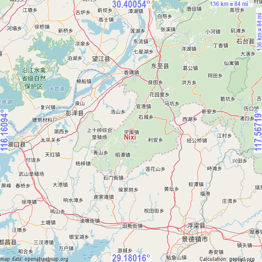
Nixi GPS coordinates[2]
29° 47' 31.956" North, 116° 51' 50.616" East
| Map corner | latitude | longitude |
|---|---|---|
| Upper-left | 30.40054°, | 116.16094° |
| Center: | 29.79221°, | 116.86406° |
| Lower-right: | 29.18016°, | 117.56719° |
| Map W x H: | 135.7×135.7 km | = 84.3×84.3mi |
| max Lat: | 53.31946° ⇑56.4% North |
| Nixi: | 29.79221° |
| min Lat: | ⇓43.6% South 18.22056° |
| min Long | Nixi | max Long |
| 75.07348° | 116.86406° | 134.28917° |
| W 65.3%⇐ | ⇒34.7% E |
Elevation
Elevation of Nixi is 52 m = 171 ft, and this is 432.8 m = 1420 ft below average elevation for this country.
| Max E: |
5622 m = 18445 ft | 70% |
| Avg. | 484.8 m = 1591 ft | |
| Nixi | 52 m = 171 ft | |
Min E: |
-3 m = -10 ft | 30% |
See also: China elevation on elevation.city.
Geographical zone
Nixi is located in North temperate zone (between Tropic of Cancer and the Arctic Circle). Distance of this Northern Tropic circle is 706.7 km =439.1 mi to South.| Distance of | km | miles | from Nixi |
|---|---|---|---|
| North Pole | 6694.5 | 4159.8 | to North |
| Arctic Circle | 4088.6 | 2540.5 | to North |
| Tropic Cancer | 706.7 | 439.1 | to South |
| Equator | 3312.6 | 2058.4 | to South |


Nearby cities:
15 places around Nixi: (largest is in red/bold)
• Dongsheng
16.8 km =10.4 mi,  284°
284°
• Guangang
14.7 km =9.1 mi,  25°
25°
• Haoshan
12.5 km =7.8 mi,  325°
325°
• Huanghua
27.1 km =16.8 mi,  286°
286°
• Huangling
28.8 km =17.9 mi,  271°
271°
• Huayuanli
24.1 km =15 mi,  37°
37°
• Lianhuashan
23 km =14.3 mi,  147°
147°
• Lihen
13.1 km =8.1 mi,  108°
108°
• Longquan
17.6 km =10.9 mi,  196°
196°
• Makeng
25.9 km =16.1 mi,  55°
55°
• Muta
18 km =11.2 mi,  95°
95°
• Qingshan
19.4 km =12.1 mi,  235°
235°
• Rangxi
19.4 km =12.1 mi,  315°
315°
• Shimenjie
25.6 km =15.9 mi, 201°
• Tielu
25.4 km =15.8 mi,  216°
216°
Sources, notices
• [Note1] Compared only with cities in China existing in our database
• [Src1] Map data: © OpenStreetMap contributors (CC-BY-SA)
• [Src2] Other city data from geonames.org with taken over terms of usage.
• [Src3] Geographical zone / Annual Mean Temperature by Robert A. Rohde @ Wikipedia
