Wangdian geodata
Wangdian (Hubei) is a seat of a fourth-order administrative division; located in China in Asia/Shanghai (GMT+8) time zone. In our database, there are 1268 cities with bigger population. Compared to other cities in China, 57.7% of cities are located further ↓South; 51.6% of cities are located further →East and 70.5% of cities have higher elevation than Wangdian. Note1


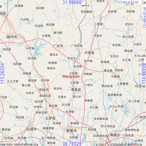
Wangdian GPS coordinates[2]
31° 23' 32.64" North, 113° 57' 59.256" East
| Map corner | latitude | longitude |
|---|---|---|
| Upper-left | 31.99068°, | 113.26334° |
| Center: | 31.3924°, | 113.96646° |
| Lower-right: | 30.79029°, | 114.66959° |
| Map W x H: | 133.5×133.5 km | = 83×83mi |
| max Lat: | 53.31946° ⇑42.3% North |
| Wangdian: | 31.3924° |
| min Lat: | ⇓57.7% South 18.22056° |
| min Long | Wangdian | max Long |
| 75.07348° | 113.96646° | 134.28917° |
| W 48.4%⇐ | ⇒51.6% E |
Elevation
Elevation of Wangdian is 50 m = 164 ft, and this is 434.8 m = 1427 ft below average elevation for this country.
| Max E: |
5622 m = 18445 ft | 70.5% |
| Avg. | 484.8 m = 1591 ft | |
| Wangdian | 50 m = 164 ft | |
Min E: |
-3 m = -10 ft | 29.5% |
See also: China elevation on elevation.city.
Geographical zone
Wangdian is located in North temperate zone (between Tropic of Cancer and the Arctic Circle). Distance of this Northern Tropic circle is 884.6 km =549.7 mi to South.| Distance of | km | miles | from Wangdian |
|---|---|---|---|
| North Pole | 6516.6 | 4049.2 | to North |
| Arctic Circle | 3910.7 | 2430 | to North |
| Tropic Cancer | 884.6 | 549.7 | to South |
| Equator | 3490.5 | 2168.9 | to South |


Nearby cities:
15 places around Wangdian: (largest is in red/bold)
• Chendian
19.7 km =12.2 mi,  225°
225°
• Chenxiang
21.2 km =13.2 mi,  297°
297°
• Doushan
21.4 km =13.3 mi,  170°
170°
• Fangfan
13.1 km =8.1 mi,  91°
91°
• Huaxi
23.8 km =14.8 mi,  205°
205°
• Huayuan
10 km =6.2 mi,  150°
150°
• Jidian
13.1 km =8.1 mi, 207°
• Jieguan
20.7 km =12.9 mi,  283°
283°
• Luodian
24.7 km =15.3 mi,  314°
314°
• Taiping
8.2 km =5.1 mi,  328°
328°
• Xiaohe
9.7 km =6 mi,  121°
121°
• Xiaowu
17.5 km =10.9 mi,  127°
127°
• Yangping
18.1 km =11.2 mi,  49°
49°
• Yangzhai
12.1 km =7.5 mi,  22°
22°
• Zhaopeng
11.4 km =7.1 mi, 281°
Sources, notices
• [Note1] Compared only with cities in China existing in our database
• [Src1] Map data: © OpenStreetMap contributors (CC-BY-SA)
• [Src2] Other city data from geonames.org with taken over terms of usage.
• [Src3] Geographical zone / Annual Mean Temperature by Robert A. Rohde @ Wikipedia
