Zhaopeng geodata
Zhaopeng (Hubei) is a seat of a fourth-order administrative division; located in China in Asia/Shanghai (GMT+8) time zone. In our database, there are 1268 cities with bigger population. Compared to other cities in China, 57.8% of cities are located further ↓South; 52.3% of cities are located further →East and 61.7% of cities have higher elevation than Zhaopeng. Note1


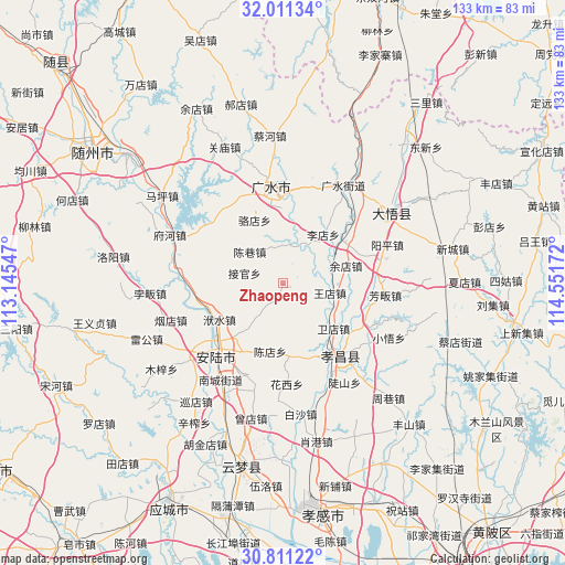
Zhaopeng GPS coordinates[2]
31° 24' 47.52" North, 113° 50' 54.924" East
| Map corner | latitude | longitude |
|---|---|---|
| Upper-left | 32.01134°, | 113.14547° |
| Center: | 31.4132°, | 113.84859° |
| Lower-right: | 30.81122°, | 114.55172° |
| Map W x H: | 133.4×133.4 km | = 82.9×82.9mi |
| max Lat: | 53.31946° ⇑42.2% North |
| Zhaopeng: | 31.4132° |
| min Lat: | ⇓57.8% South 18.22056° |
| min Long | Zhaopeng | max Long |
| 75.07348° | 113.84859° | 134.28917° |
| W 47.7%⇐ | ⇒52.3% E |
Elevation
Elevation of Zhaopeng is 89 m = 292 ft, and this is 395.8 m = 1299 ft below average elevation for this country.
| Max E: |
5622 m = 18445 ft | 61.7% |
| Avg. | 484.8 m = 1591 ft | |
| Zhaopeng | 89 m = 292 ft | |
Min E: |
-3 m = -10 ft | 38.3% |
See also: China elevation on elevation.city.
Geographical zone
Zhaopeng is located in North temperate zone (between Tropic of Cancer and the Arctic Circle). Distance of this Northern Tropic circle is 886.9 km =551.1 mi to South.| Distance of | km | miles | from Zhaopeng |
|---|---|---|---|
| North Pole | 6514.2 | 4047.7 | to North |
| Arctic Circle | 3908.4 | 2428.6 | to North |
| Tropic Cancer | 886.9 | 551.1 | to South |
| Equator | 3492.8 | 2170.3 | to South |


Nearby cities:
15 places around Zhaopeng: (largest is in red/bold)
• Anlu
23.7 km =14.7 mi,  223°
223°
• Chendian
16.4 km =10.2 mi,  190°
190°
• Chenxiang
10.7 km =6.6 mi,  313°
313°
• Fushui
17.2 km =10.7 mi,  240°
240°
• Huayuan
19.5 km =12.1 mi,  124°
124°
• Jidian
14.9 km =9.3 mi,  159°
159°
• Jieguan
9.3 km =5.8 mi,  285°
285°
• Lidian
23.6 km =14.7 mi,  201°
201°
• Luodian
16.3 km =10.1 mi,  336°
336°
• Pinglin
23.1 km =14.4 mi,  270°
270°
• Shili
22.5 km =14 mi,  7°
7°
• Taiping
8.3 km =5.2 mi,  55°
55°
• Wangdian
11.4 km =7.1 mi,  101°
101°
• Xiaohe
20.8 km =12.9 mi,  110°
110°
• Yangzhai
18.2 km =11.3 mi, 60°
Sources, notices
• [Note1] Compared only with cities in China existing in our database
• [Src1] Map data: © OpenStreetMap contributors (CC-BY-SA)
• [Src2] Other city data from geonames.org with taken over terms of usage.
• [Src3] Geographical zone / Annual Mean Temperature by Robert A. Rohde @ Wikipedia
