Luodian geodata
Luodian (Hubei) is a seat of a fourth-order administrative division; located in China in Asia/Shanghai (GMT+8) time zone. In our database, there are 1268 cities with bigger population. Compared to other cities in China, 58.7% of cities are located further ↓South; 52.6% of cities are located further →East and 60.4% of cities have higher elevation than Luodian. Note1


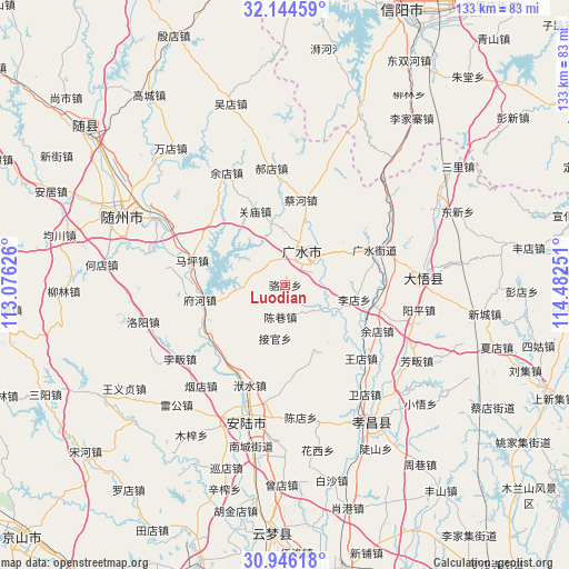
Luodian GPS coordinates[2]
31° 32' 50.316" North, 113° 46' 45.768" East
| Map corner | latitude | longitude |
|---|---|---|
| Upper-left | 32.14459°, | 113.07626° |
| Center: | 31.54731°, | 113.77938° |
| Lower-right: | 30.94618°, | 114.48251° |
| Map W x H: | 133.3×133.3 km | = 82.8×82.8mi |
| max Lat: | 53.31946° ⇑41.3% North |
| Luodian: | 31.54731° |
| min Lat: | ⇓58.7% South 18.22056° |
| min Long | Luodian | max Long |
| 75.07348° | 113.77938° | 134.28917° |
| W 47.4%⇐ | ⇒52.6% E |
Elevation
Elevation of Luodian is 96 m = 315 ft, and this is 388.8 m = 1276 ft below average elevation for this country.
| Max E: |
5622 m = 18445 ft | 60.4% |
| Avg. | 484.8 m = 1591 ft | |
| Luodian | 96 m = 315 ft | |
Min E: |
-3 m = -10 ft | 39.6% |
See also: China elevation on elevation.city.
Geographical zone
Luodian is located in North temperate zone (between Tropic of Cancer and the Arctic Circle). Distance of this Northern Tropic circle is 901.8 km =560.4 mi to South.| Distance of | km | miles | from Luodian |
|---|---|---|---|
| North Pole | 6499.3 | 4038.5 | to North |
| Arctic Circle | 3893.4 | 2419.2 | to North |
| Tropic Cancer | 901.8 | 560.4 | to South |
| Equator | 3507.7 | 2179.6 | to South |


Nearby cities:
15 places around Luodian: (largest is in red/bold)
• Baolin
16.5 km =10.3 mi,  31°
31°
• Caihe
20.1 km =12.5 mi,  9°
9°
• Changling
19 km =11.8 mi,  260°
260°
• Chenxiang
7.6 km =4.7 mi,  188°
188°
• Fuhe
20.6 km =12.8 mi, 258°
• Guangshui
22.2 km =13.8 mi,  68°
68°
• Guanmiao
18.9 km =11.7 mi,  338°
338°
• Jieguan
12.7 km =7.9 mi, 190°
• Maping
22.5 km =14 mi,  285°
285°
• Pinglin
22.1 km =13.7 mi,  228°
228°
• Shili
12.1 km =7.5 mi,  52°
52°
• Taiping
16.9 km =10.5 mi,  127°
127°
• Xinglong
24.4 km =15.2 mi,  319°
319°
• Yangzhai
23.2 km =14.4 mi,  105°
105°
• Zhaopeng
16.3 km =10.1 mi,  156°
156°
Sources, notices
• [Note1] Compared only with cities in China existing in our database
• [Src1] Map data: © OpenStreetMap contributors (CC-BY-SA)
• [Src2] Other city data from geonames.org with taken over terms of usage.
• [Src3] Geographical zone / Annual Mean Temperature by Robert A. Rohde @ Wikipedia
