Wangcun geodata
Wangcun (Henan) is a seat of a fourth-order administrative division; located in China in Asia/Shanghai (GMT+8) time zone. In our database, there are 1268 cities with bigger population. Compared to other cities in China, 66.2% of cities are located further ↓South; 60.5% of cities are located further →East and 52.4% of cities have higher elevation than Wangcun. Note1


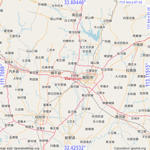
Wangcun GPS coordinates[2]
33° 1' 0.696" North, 112° 24' 43.272" East
| Map corner | latitude | longitude |
|---|---|---|
| Upper-left | 33.60446°, | 111.7089° |
| Center: | 33.01686°, | 112.41202° |
| Lower-right: | 32.42532°, | 113.11515° |
| Map W x H: | 131.1×131.1 km | = 81.5×81.5mi |
| max Lat: | 53.31946° ⇑33.8% North |
| Wangcun: | 33.01686° |
| min Lat: | ⇓66.2% South 18.22056° |
| min Long | Wangcun | max Long |
| 75.07348° | 112.41202° | 134.28917° |
| W 39.5%⇐ | ⇒60.5% E |
Elevation
Elevation of Wangcun is 147 m = 482 ft, and this is 337.8 m = 1108 ft below average elevation for this country.
| Max E: |
5622 m = 18445 ft | 52.4% |
| Avg. | 484.8 m = 1591 ft | |
| Wangcun | 147 m = 482 ft | |
Min E: |
-3 m = -10 ft | 47.6% |
See also: China elevation on elevation.city.
Geographical zone
Wangcun is located in North temperate zone (between Tropic of Cancer and the Arctic Circle). Distance of this Northern Tropic circle is 1065.2 km =661.9 mi to South.| Distance of | km | miles | from Wangcun |
|---|---|---|---|
| North Pole | 6335.9 | 3936.9 | to North |
| Arctic Circle | 3730 | 2317.7 | to North |
| Tropic Cancer | 1065.2 | 661.9 | to South |
| Equator | 3671.1 | 2281.1 | to South |


Nearby cities:
15 places around Wangcun: (largest is in red/bold)
• Angao
11.3 km =7 mi,  346°
346°
• Chaobei
28.9 km =18 mi,  275°
275°
• Chengjiao
14.9 km =9.3 mi, 280°
• Huancheng
11.9 km =7.4 mi,  91°
91°
• Jingang
7.8 km =4.8 mi, 91°
• Laozhuang
18.2 km =11.3 mi,  317°
317°
• Liuquan
7.9 km =4.9 mi,  295°
295°
• Longxing
20.1 km =12.5 mi,  358°
358°
• Nanyang
11.5 km =7.1 mi,  102°
102°
• Pushan
20.5 km =12.7 mi,  56°
56°
• Shifosi
24.9 km =15.5 mi,  286°
286°
• Xiezhuang
14.9 km =9.3 mi,  8°
8°
• Yangying
22.9 km =14.2 mi,  265°
265°
• Zhenping Chengguanzhen
16.8 km =10.4 mi, 276°
• Zheshan
6.4 km =4 mi, 298°
Sources, notices
• [Note1] Compared only with cities in China existing in our database
• [Src1] Map data: © OpenStreetMap contributors (CC-BY-SA)
• [Src2] Other city data from geonames.org with taken over terms of usage.
• [Src3] Geographical zone / Annual Mean Temperature by Robert A. Rohde @ Wikipedia
