Nanyang geodata
Nanyang (Henan) is a populated place; located in China in Asia/Shanghai (GMT+8) time zone. With population of 251,532 people, there are 201 cities with bigger population in this country. Compared to other cities in China, 66% of cities are located further ↓South; 59.9% of cities are located further →East and 55.1% of cities have higher elevation than Nanyang. Note1


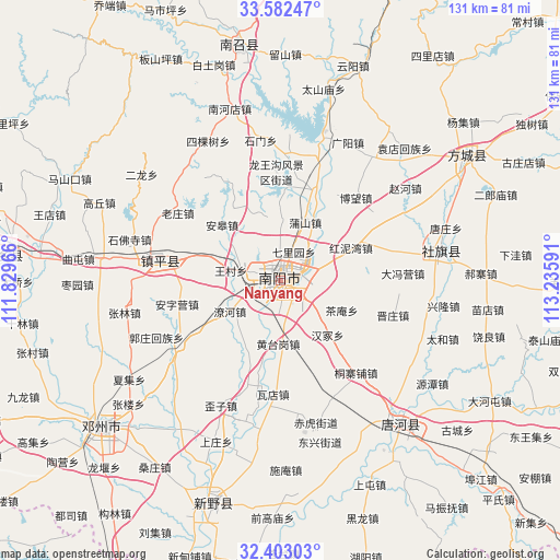
Nanyang GPS coordinates[2]
32° 59' 40.992" North, 112° 31' 58.008" East
| Map corner | latitude | longitude |
|---|---|---|
| Upper-left | 33.58247°, | 111.82966° |
| Center: | 32.99472°, | 112.53278° |
| Lower-right: | 32.40303°, | 113.23591° |
| Map W x H: | 131.1×131.1 km | = 81.5×81.5mi |
| max Lat: | 53.31946° ⇑34% North |
| Nanyang: | 32.99472° |
| min Lat: | ⇓66% South 18.22056° |
| min Long | Nanyang | max Long |
| 75.07348° | 112.53278° | 134.28917° |
| W 40.1%⇐ | ⇒59.9% E |
Elevation
Elevation of Nanyang is 131 m = 430 ft, and this is 353.8 m = 1161 ft below average elevation for this country.
| Max E: |
5622 m = 18445 ft | 55.1% |
| Avg. | 484.8 m = 1591 ft | |
| Nanyang | 131 m = 430 ft | |
Min E: |
-3 m = -10 ft | 44.9% |
See also: Nanyang elevation on elevation.city.
Geographical zone
Nanyang is located in North temperate zone (between Tropic of Cancer and the Arctic Circle). Distance of this Northern Tropic circle is 1062.7 km =660.3 mi to South.| Distance of | km | miles | from Nanyang |
|---|---|---|---|
| North Pole | 6338.4 | 3938.5 | to North |
| Arctic Circle | 3732.5 | 2319.3 | to North |
| Tropic Cancer | 1062.7 | 660.3 | to South |
| Equator | 3668.7 | 2279.6 | to South |


Nearby cities:
15 places around Nanyang: (largest is in red/bold)
• Angao
19.4 km =12.1 mi,  314°
314°
• Bowang
28.1 km =17.5 mi,  44°
44°
• Chengjiao
26.4 km =16.4 mi,  281°
281°
• Dafengying
28.8 km =17.9 mi,  87°
87°
• Huancheng
2.3 km =1.4 mi,  15°
15°
• Jingang
4.1 km =2.5 mi,  303°
303°
• Laozhuang
28.4 km =17.6 mi, 303°
• Liuquan
19.3 km =12 mi,  287°
287°
• Longxing
25.4 km =15.8 mi,  332°
332°
• Pushan
15.1 km =9.4 mi, 22°
• Qiaotou
26.7 km =16.6 mi,  75°
75°
• Wangcun
11.5 km =7.1 mi, 282°
• Xiezhuang
19.4 km =12.1 mi, 332°
• Zhenping Chengguanzhen
28.3 km =17.6 mi, 278°
• Zheshan
17.8 km =11.1 mi, 288°
Sources, notices
• [Note1] Compared only with cities in China existing in our database
• [Src1] Map data: © OpenStreetMap contributors (CC-BY-SA)
• [Src2] Other city data from geonames.org with taken over terms of usage.
• [Src3] Geographical zone / Annual Mean Temperature by Robert A. Rohde @ Wikipedia
