Fuding geodata
Fuding (Fujian) is a seat of a third-order administrative division; located in China in Asia/Shanghai (GMT+8) time zone. With population of 63,250 people, there are 684 cities with bigger population in this country. Compared to other cities in China, 77.3% of cities are located further ↑North; 83.3% of cities are located further ←West and 86.9% of cities have higher elevation than Fuding. Note1


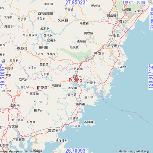
Fuding GPS coordinates[2]
27° 19' 38.424" North, 120° 12' 50.364" East
| Map corner | latitude | longitude |
|---|---|---|
| Upper-left | 27.95023°, | 119.51087° |
| Center: | 27.32734°, | 120.21399° |
| Lower-right: | 26.70093°, | 120.91712° |
| Map W x H: | 138.9×138.9 km | = 86.3×86.3mi |
| max Lat: | 53.31946° ⇑77.3% North |
| Fuding: | 27.32734° |
| min Lat: | ⇓22.7% South 18.22056° |
| min Long | Fuding | max Long |
| 75.07348° | 120.21399° | 134.28917° |
| W 83.3%⇐ | ⇒16.7% E |
Elevation
Elevation of Fuding is 13 m = 43 ft, and this is 471.8 m = 1548 ft below average elevation for this country.
| Max E: |
5622 m = 18445 ft | 86.9% |
| Avg. | 484.8 m = 1591 ft | |
| Fuding | 13 m = 43 ft | |
Min E: |
-3 m = -10 ft | 13.1% |
See also: Fuding elevation on elevation.city.
Geographical zone
Fuding is located in North temperate zone (between Tropic of Cancer and the Arctic Circle). Distance of this Northern Tropic circle is 432.6 km =268.8 mi to South.| Distance of | km | miles | from Fuding |
|---|---|---|---|
| North Pole | 6968.5 | 4330 | to North |
| Arctic Circle | 4362.7 | 2710.9 | to North |
| Tropic Cancer | 432.6 | 268.8 | to South |
| Equator | 3038.5 | 1888 | to South |


Nearby cities:
15 places around Fuding: (largest is in red/bold)
• Da’an
35.7 km =22.2 mi,  293°
293°
• Dongxi
27.3 km =17 mi, 293°
• Dongyuan
33.9 km =21.1 mi,  248°
248°
• Fengyang
31.2 km =19.4 mi,  312°
312°
• Liufeng
22.8 km =14.2 mi, 288°
• Menlou’ao
35.5 km =22.1 mi, 289°
• Sankui
31.8 km =19.8 mi, 290°
• Shiyang
31.7 km =19.7 mi,  278°
278°
• Wanpai
28.7 km =17.8 mi,  274°
274°
• Wengshan
35.9 km =22.3 mi,  318°
318°
• Xiyang
35.7 km =22.2 mi, 289°
• Xuexi
30.4 km =18.9 mi, 284°
• Yacheng
37.8 km =23.5 mi,  183°
183°
• Zhayang
25.4 km =15.8 mi, 247°
• Zherong
33 km =20.5 mi, 252°
Sources, notices
• [Note1] Compared only with cities in China existing in our database
• [Src1] Map data: © OpenStreetMap contributors (CC-BY-SA)
• [Src2] Other city data from geonames.org with taken over terms of usage.
• [Src3] Geographical zone / Annual Mean Temperature by Robert A. Rohde @ Wikipedia
