Wengshan geodata
Wengshan (Zhejiang) is a seat of a fourth-order administrative division; located in China in Asia/Shanghai (GMT+8) time zone. In our database, there are 1268 cities with bigger population. Compared to other cities in China, 76.3% of cities are located further ↑North; 81.8% of cities are located further ←West and 82.3% of cities have lower elevation than Wengshan. Note1


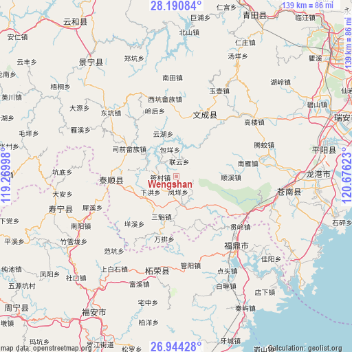
Wengshan GPS coordinates[2]
27° 34' 9.588" North, 119° 58' 23.16" East
| Map corner | latitude | longitude |
|---|---|---|
| Upper-left | 28.19084°, | 119.26998° |
| Center: | 27.56933°, | 119.9731° |
| Lower-right: | 26.94428°, | 120.67623° |
| Map W x H: | 138.6×138.6 km | = 86.1×86.1mi |
| max Lat: | 53.31946° ⇑76.3% North |
| Wengshan: | 27.56933° |
| min Lat: | ⇓23.7% South 18.22056° |
| min Long | Wengshan | max Long |
| 75.07348° | 119.9731° | 134.28917° |
| W 81.8%⇐ | ⇒18.2% E |
Elevation
Elevation of Wengshan is 804 m = 2638 ft, and this is 319.2 m = 1047 ft above average elevation for this country.
| Max E: |
5622 m = 18445 ft | 17.7% |
| Wengshan | 804 m 2638 ft | |
| Avg. | 484.8 m = 1591 ft | |
Min E: |
-3 m = -10 ft | 82.3% |
See also: China elevation on elevation.city.
Geographical zone
Wengshan is located in North temperate zone (between Tropic of Cancer and the Arctic Circle). Distance of this Northern Tropic circle is 459.5 km =285.5 mi to South.| Distance of | km | miles | from Wengshan |
|---|---|---|---|
| North Pole | 6941.6 | 4313.3 | to North |
| Arctic Circle | 4335.8 | 2694.1 | to North |
| Tropic Cancer | 459.5 | 285.5 | to South |
| Equator | 3065.4 | 1904.8 | to South |


Nearby cities:
15 places around Wengshan: (largest is in red/bold)
• Baizhang
15.4 km =9.6 mi,  308°
308°
• Baoyang
11 km =6.8 mi,  346°
346°
• Da’an
15.7 km =9.8 mi,  215°
215°
• Dongxi
16.2 km =10.1 mi,  184°
184°
• Fengmen
18.2 km =11.3 mi,  321°
321°
• Fengyang
6.1 km =3.8 mi,  173°
173°
• Lianyun
6.1 km =3.8 mi,  10°
10°
• Menlou’ao
17.9 km =11.1 mi,  212°
212°
• Sankui
16.8 km =10.4 mi,  200°
200°
• Xiahong
11.9 km =7.4 mi,  239°
239°
• Xiaocun
6.4 km =4 mi,  267°
267°
• Xinpu
7.7 km =4.8 mi,  328°
328°
• Xiyang
17.8 km =11.1 mi, 213°
• Yunhu
17.7 km =11 mi,  342°
342°
• Zhishan
17.2 km =10.7 mi, 342°
Sources, notices
• [Note1] Compared only with cities in China existing in our database
• [Src1] Map data: © OpenStreetMap contributors (CC-BY-SA)
• [Src2] Other city data from geonames.org with taken over terms of usage.
• [Src3] Geographical zone / Annual Mean Temperature by Robert A. Rohde @ Wikipedia
