Tonghu geodata
Tonghu (Guangdong) is a seat of a fourth-order administrative division; located in China in Asia/Shanghai (GMT+8) time zone. In our database, there are 1268 cities with bigger population. Compared to other cities in China, 94% of cities are located further ↑North; 50.3% of cities are located further →East and 86.9% of cities have higher elevation than Tonghu. Note1


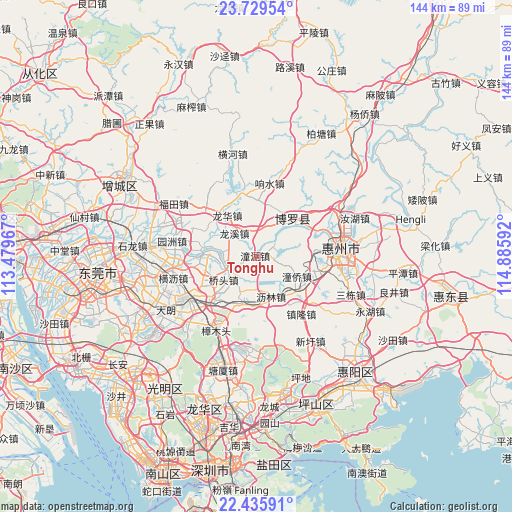
Tonghu GPS coordinates[2]
23° 5' 3.408" North, 114° 10' 58.044" East
| Map corner | latitude | longitude |
|---|---|---|
| Upper-left | 23.72954°, | 113.47967° |
| Center: | 23.08428°, | 114.18279° |
| Lower-right: | 22.43591°, | 114.88592° |
| Map W x H: | 143.8×143.8 km | = 89.4×89.4mi |
| max Lat: | 53.31946° ⇑94% North |
| Tonghu: | 23.08428° |
| min Lat: | ⇓6% South 18.22056° |
| min Long | Tonghu | max Long |
| 75.07348° | 114.18279° | 134.28917° |
| W 49.7%⇐ | ⇒50.3% E |
Elevation
Elevation of Tonghu is 13 m = 43 ft, and this is 471.8 m = 1548 ft below average elevation for this country.
| Max E: |
5622 m = 18445 ft | 86.9% |
| Avg. | 484.8 m = 1591 ft | |
| Tonghu | 13 m = 43 ft | |
Min E: |
-3 m = -10 ft | 13.1% |
See also: China elevation on elevation.city.
Geographical zone
Tonghu is located in North Torrid zone (between Equator and Tropic of Cancer). Distance of this Northern Tropic circle is 39.2 km =24.4 mi to North.| Distance of | km | miles | from Tonghu |
|---|---|---|---|
| North Pole | 7440.3 | 4623.2 | to North |
| Arctic Circle | 4834.4 | 3004 | to North |
| Tropic Cancer | 39.2 | 24.4 | to North |
| Equator | 2566.7 | 1594.9 | to South |


Nearby cities:
15 places around Tonghu: (largest is in red/bold)
• Changning
21.4 km =13.3 mi,  316°
316°
• Chenjiang
13.9 km =8.6 mi,  116°
116°
• Huihuan
19.7 km =12.2 mi,  106°
106°
• Huzhen
18.4 km =11.4 mi,  349°
349°
• Lilin
10.6 km =6.6 mi,  161°
161°
• Longfeng
20.4 km =12.7 mi,  93°
93°
• Longhua
14.6 km =9.1 mi,  325°
325°
• Longxi
9 km =5.6 mi, 316°
• Luoyang
12.7 km =7.9 mi,  46°
46°
• Qiaotou
11.4 km =7.1 mi,  234°
234°
• Qishi
16.5 km =10.3 mi,  265°
265°
• Tongqiao
17.4 km =10.8 mi, 114°
• Xiangshui
20.8 km =12.9 mi,  10°
10°
• Xiegang
14.4 km =8.9 mi,  197°
197°
• Zhenlong
20.5 km =12.7 mi,  141°
141°
Sources, notices
• [Note1] Compared only with cities in China existing in our database
• [Src1] Map data: © OpenStreetMap contributors (CC-BY-SA)
• [Src2] Other city data from geonames.org with taken over terms of usage.
• [Src3] Geographical zone / Annual Mean Temperature by Robert A. Rohde @ Wikipedia
