Luoyang geodata
Luoyang (Guangdong) is a seat of a third-order administrative division; located in China in Asia/Shanghai (GMT+8) time zone. With population of 123,144 people, there are 358 cities with bigger population in this country. Compared to other cities in China, 93.7% of cities are located further ↑North; 50.2% of cities are located further ←West and 84.9% of cities have higher elevation than Luoyang. Note1


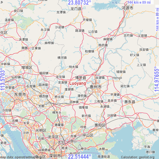
Luoyang GPS coordinates[2]
23° 9' 44.784" North, 114° 16' 24.312" East
| Map corner | latitude | longitude |
|---|---|---|
| Upper-left | 23.80732°, | 113.5703° |
| Center: | 23.16244°, | 114.27342° |
| Lower-right: | 22.51444°, | 114.97655° |
| Map W x H: | 143.8×143.8 km | = 89.4×89.4mi |
| max Lat: | 53.31946° ⇑93.7% North |
| Luoyang: | 23.16244° |
| min Lat: | ⇓6.3% South 18.22056° |
| min Long | Luoyang | max Long |
| 75.07348° | 114.27342° | 134.28917° |
| W 50.2%⇐ | ⇒49.8% E |
Elevation
Elevation of Luoyang is 16 m = 52 ft, and this is 468.8 m = 1538 ft below average elevation for this country.
| Max E: |
5622 m = 18445 ft | 84.9% |
| Avg. | 484.8 m = 1591 ft | |
| Luoyang | 16 m = 52 ft | |
Min E: |
-3 m = -10 ft | 15.1% |
See also: Luoyang elevation on elevation.city.
Geographical zone
Luoyang is located in North Torrid zone (between Equator and Tropic of Cancer). Distance of this Northern Tropic circle is 30.5 km =19 mi to North.| Distance of | km | miles | from Luoyang |
|---|---|---|---|
| North Pole | 7431.6 | 4617.8 | to North |
| Arctic Circle | 4825.8 | 2998.6 | to North |
| Tropic Cancer | 30.5 | 19 | to North |
| Equator | 2575.4 | 1600.3 | to South |


Nearby cities:
15 places around Luoyang: (largest is in red/bold)
• Chenjiang
15.2 km =9.4 mi,  167°
167°
• Henan’an
17.9 km =11.1 mi,  123°
123°
• Huihuan
17.3 km =10.7 mi,  146°
146°
• Huizhou
15.6 km =9.7 mi,  111°
111°
• Huzhen
15.7 km =9.8 mi,  306°
306°
• Lilin
19.7 km =12.2 mi,  197°
197°
• Longfeng
14.9 km =9.3 mi,  131°
131°
• Longhua
17.8 km =11.1 mi,  280°
280°
• Longxi
15.6 km =9.7 mi,  261°
261°
• Qiaotou
24 km =14.9 mi,  230°
230°
• Ruhu
18.2 km =11.3 mi,  82°
82°
• Tonghu
12.7 km =7.9 mi, 226°
• Tongqiao
17.2 km =10.7 mi,  157°
157°
• Xiangshui
13.1 km =8.1 mi,  334°
334°
• Xiaojinkou
12.9 km =8 mi,  70°
70°
In other languages:
- In Russian: Лоян
- In Chinese: Fu-ch’eng-chen, Hsien-ch’eng-chen, Fu-ch’eng, Po-ch’eng-chen
Sources, notices
• [Note1] Compared only with cities in China existing in our database
• [Src1] Map data: © OpenStreetMap contributors (CC-BY-SA)
• [Src2] Other city data from geonames.org with taken over terms of usage.
• [Src3] Geographical zone / Annual Mean Temperature by Robert A. Rohde @ Wikipedia
