Xiangshui geodata
Xiangshui (Guangdong) is a seat of a fourth-order administrative division; located in China in Asia/Shanghai (GMT+8) time zone. In our database, there are 1268 cities with bigger population. Compared to other cities in China, 93.2% of cities are located further ↑North; 50% of cities are located further ←West and 77.7% of cities have higher elevation than Xiangshui. Note1


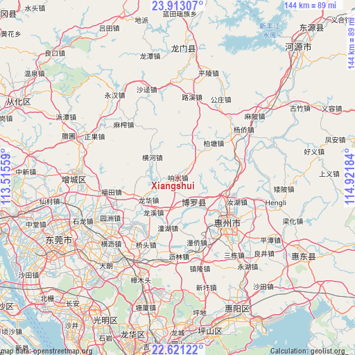
Xiangshui GPS coordinates[2]
23° 16' 7.356" North, 114° 13' 7.356" East
| Map corner | latitude | longitude |
|---|---|---|
| Upper-left | 23.91307°, | 113.51559° |
| Center: | 23.26871°, | 114.21871° |
| Lower-right: | 22.62122°, | 114.92184° |
| Map W x H: | 143.6×143.6 km | = 89.2×89.2mi |
| max Lat: | 53.31946° ⇑93.2% North |
| Xiangshui: | 23.26871° |
| min Lat: | ⇓6.8% South 18.22056° |
| min Long | Xiangshui | max Long |
| 75.07348° | 114.21871° | 134.28917° |
| W 50%⇐ | ⇒50% E |
Elevation
Elevation of Xiangshui is 31 m = 102 ft, and this is 453.8 m = 1489 ft below average elevation for this country.
| Max E: |
5622 m = 18445 ft | 77.7% |
| Avg. | 484.8 m = 1591 ft | |
| Xiangshui | 31 m = 102 ft | |
Min E: |
-3 m = -10 ft | 22.3% |
See also: China elevation on elevation.city.
Geographical zone
Xiangshui is located in North Torrid zone (between Equator and Tropic of Cancer). Distance of this Northern Tropic circle is 18.7 km =11.6 mi to North.| Distance of | km | miles | from Xiangshui |
|---|---|---|---|
| North Pole | 7419.8 | 4610.4 | to North |
| Arctic Circle | 4813.9 | 2991.2 | to North |
| Tropic Cancer | 18.7 | 11.6 | to North |
| Equator | 2587.2 | 1607.6 | to South |


Nearby cities:
15 places around Xiangshui: (largest is in red/bold)
• Baitang
20.1 km =12.5 mi,  45°
45°
• Changning
19.1 km =11.9 mi,  254°
254°
• Chenjiang
28.1 km =17.5 mi,  161°
161°
• Futian
27.5 km =17.1 mi,  258°
258°
• Henghe
13.3 km =8.3 mi,  308°
308°
• Huizhou
26.6 km =16.5 mi,  131°
131°
• Huzhen
7.4 km =4.6 mi, 250°
• Longfeng
27.4 km =17 mi,  142°
142°
• Longhua
14.7 km =9.1 mi,  234°
234°
• Longxi
17.2 km =10.7 mi,  215°
215°
• Luoyang
13.1 km =8.1 mi,  154°
154°
• Ruhu
25.5 km =15.8 mi,  111°
111°
• Taimei
26.3 km =16.3 mi,  76°
76°
• Tonghu
20.8 km =12.9 mi,  190°
190°
• Xiaojinkou
19.2 km =11.9 mi, 112°
Sources, notices
• [Note1] Compared only with cities in China existing in our database
• [Src1] Map data: © OpenStreetMap contributors (CC-BY-SA)
• [Src2] Other city data from geonames.org with taken over terms of usage.
• [Src3] Geographical zone / Annual Mean Temperature by Robert A. Rohde @ Wikipedia
