Tianwang geodata
Tianwang (Shaanxi) is a seat of a fourth-order administrative division; located in China in Asia/Shanghai (GMT+8) time zone. In our database, there are 1268 cities with bigger population. Compared to other cities in China, 71.5% of cities are located further ↓South; 82.3% of cities are located further →East and 76.1% of cities have lower elevation than Tianwang. Note1


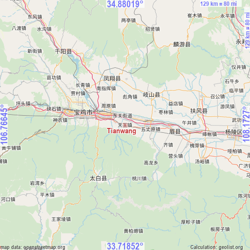
Tianwang GPS coordinates[2]
34° 18' 4.896" North, 107° 28' 10.452" East
| Map corner | latitude | longitude |
|---|---|---|
| Upper-left | 34.88019°, | 106.76645° |
| Center: | 34.30136°, | 107.46957° |
| Lower-right: | 33.71852°, | 108.1727° |
| Map W x H: | 129.2×129.2 km | = 80.3×80.3mi |
| max Lat: | 53.31946° ⇑28.5% North |
| Tianwang: | 34.30136° |
| min Lat: | ⇓71.5% South 18.22056° |
| min Long | Tianwang | max Long |
| 75.07348° | 107.46957° | 134.28917° |
| W 17.7%⇐ | ⇒82.3% E |
Elevation
Elevation of Tianwang is 549 m = 1801 ft, and this is 64.2 m = 211 ft above average elevation for this country.
| Max E: |
5622 m = 18445 ft | 23.9% |
| Tianwang | 549 m 1801 ft | |
| Avg. | 484.8 m = 1591 ft | |
Min E: |
-3 m = -10 ft | 76.1% |
See also: China elevation on elevation.city.
Geographical zone
Tianwang is located in North temperate zone (between Tropic of Cancer and the Arctic Circle). Distance of this Northern Tropic circle is 1208 km =750.6 mi to South.| Distance of | km | miles | from Tianwang |
|---|---|---|---|
| North Pole | 6193.1 | 3848.2 | to North |
| Arctic Circle | 3587.2 | 2229 | to North |
| Tropic Cancer | 1208 | 750.6 | to South |
| Equator | 3814 | 2369.9 | to South |


Nearby cities:
15 places around Tianwang: (largest is in red/bold)
• Bayu
18.1 km =11.2 mi,  282°
282°
• Biaojiao
15.1 km =9.4 mi,  9°
9°
• Caijiapo
12 km =7.5 mi,  76°
76°
• Caojia
14.1 km =8.8 mi,  116°
116°
• Diaowei
4.4 km =2.7 mi,  105°
105°
• Guodian
17.7 km =11 mi,  346°
346°
• Guowang
10.6 km =6.6 mi,  29°
29°
• Guozhen
12.4 km =7.7 mi,  305°
305°
• Muyi
10.1 km =6.3 mi,  343°
343°
• Panxi
6.5 km =4 mi,  291°
291°
• Qianhe
18.5 km =11.5 mi,  303°
303°
• Wuzhangyuan
13.3 km =8.3 mi,  98°
98°
• Yangping
4.5 km =2.8 mi,  24°
24°
• Yongchuan
17 km =10.6 mi,  65°
65°
• Zhouyuan
13.5 km =8.4 mi,  320°
320°
Sources, notices
• [Note1] Compared only with cities in China existing in our database
• [Src1] Map data: © OpenStreetMap contributors (CC-BY-SA)
• [Src2] Other city data from geonames.org with taken over terms of usage.
• [Src3] Geographical zone / Annual Mean Temperature by Robert A. Rohde @ Wikipedia
