Guozhen geodata
Guozhen (Shaanxi) is a seat of a third-order administrative division; located in China in Asia/Shanghai (GMT+8) time zone. With population of 85,415 people, there are 499 cities with bigger population in this country. Compared to other cities in China, 71.9% of cities are located further ↓South; 82.6% of cities are located further →East and 76.2% of cities have lower elevation than Guozhen. Note1


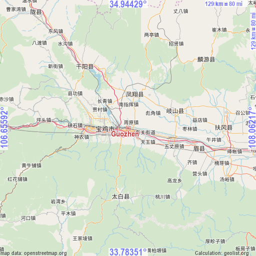
Guozhen GPS coordinates[2]
34° 21' 57.276" North, 107° 21' 32.544" East
| Map corner | latitude | longitude |
|---|---|---|
| Upper-left | 34.94429°, | 106.65592° |
| Center: | 34.36591°, | 107.35904° |
| Lower-right: | 33.78351°, | 108.06217° |
| Map W x H: | 129.1×129.1 km | = 80.2×80.2mi |
| max Lat: | 53.31946° ⇑28.1% North |
| Guozhen: | 34.36591° |
| min Lat: | ⇓71.9% South 18.22056° |
| min Long | Guozhen | max Long |
| 75.07348° | 107.35904° | 134.28917° |
| W 17.4%⇐ | ⇒82.6% E |
Elevation
Elevation of Guozhen is 551 m = 1808 ft, and this is 66.2 m = 217 ft above average elevation for this country.
| Max E: |
5622 m = 18445 ft | 23.8% |
| Guozhen | 551 m 1808 ft | |
| Avg. | 484.8 m = 1591 ft | |
Min E: |
-3 m = -10 ft | 76.2% |
See also: Guozhen elevation on elevation.city.
Geographical zone
Guozhen is located in North temperate zone (between Tropic of Cancer and the Arctic Circle). Distance of this Northern Tropic circle is 1215.2 km =755.1 mi to South.| Distance of | km | miles | from Guozhen |
|---|---|---|---|
| North Pole | 6185.9 | 3843.7 | to North |
| Arctic Circle | 3580 | 2224.5 | to North |
| Tropic Cancer | 1215.2 | 755.1 | to South |
| Equator | 3821.1 | 2374.3 | to South |


Nearby cities:
15 places around Guozhen: (largest is in red/bold)
• Baoji
11.2 km =7 mi,  271°
271°
• Bayu
8.2 km =5.1 mi,  246°
246°
• Biaojiao
14.8 km =9.2 mi,  58°
58°
• Chencang
13.9 km =8.6 mi, 271°
• Guodian
11.8 km =7.3 mi,  31°
31°
• Guowang
15.5 km =9.6 mi,  82°
82°
• Maying
12.2 km =7.6 mi,  257°
257°
• Muyi
7.7 km =4.8 mi,  71°
71°
• Nanzhihui
11.7 km =7.3 mi,  358°
358°
• Panlong
15.9 km =9.9 mi,  291°
291°
• Panxi
6.3 km =3.9 mi,  139°
139°
• Qianhe
6 km =3.7 mi,  300°
300°
• Tianwang
12.4 km =7.7 mi,  125°
125°
• Yangping
12.4 km =7.7 mi,  104°
104°
• Zhouyuan
3.7 km =2.3 mi, 25°
Sources, notices
• [Note1] Compared only with cities in China existing in our database
• [Src1] Map data: © OpenStreetMap contributors (CC-BY-SA)
• [Src2] Other city data from geonames.org with taken over terms of usage.
• [Src3] Geographical zone / Annual Mean Temperature by Robert A. Rohde @ Wikipedia
