Taocun geodata
Taocun (Shanxi) is a seat of a fourth-order administrative division; located in China in Asia/Shanghai (GMT+8) time zone. In our database, there are 1268 cities with bigger population. Compared to other cities in China, 84.5% of cities are located further ↓South; 60.3% of cities are located further →East and 87.8% of cities have lower elevation than Taocun. Note1


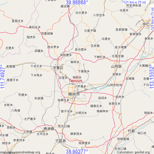
Taocun GPS coordinates[2]
39° 26' 52.224" North, 112° 27' 8.604" East
| Map corner | latitude | longitude |
|---|---|---|
| Upper-left | 39.98868°, | 111.74927° |
| Center: | 39.44784°, | 112.45239° |
| Lower-right: | 38.90277°, | 113.15552° |
| Map W x H: | 120.7×120.7 km | = 75×75mi |
| max Lat: | 53.31946° ⇑15.5% North |
| Taocun: | 39.44784° |
| min Lat: | ⇓84.5% South 18.22056° |
| min Long | Taocun | max Long |
| 75.07348° | 112.45239° | 134.28917° |
| W 39.7%⇐ | ⇒60.3% E |
Elevation
Elevation of Taocun is 1171 m = 3842 ft, and this is 686.2 m = 2251 ft above average elevation for this country.
| Max E: |
5622 m = 18445 ft | 12.2% |
| Taocun | 1171 m 3842 ft | |
| Avg. | 484.8 m = 1591 ft | |
Min E: |
-3 m = -10 ft | 87.8% |
See also: China elevation on elevation.city.
Geographical zone
Taocun is located in North temperate zone (between Tropic of Cancer and the Arctic Circle). Distance of this Northern Tropic circle is 1780.3 km =1106.2 mi to South.| Distance of | km | miles | from Taocun |
|---|---|---|---|
| North Pole | 5620.9 | 3492.7 | to North |
| Arctic Circle | 3015 | 1873.4 | to North |
| Tropic Cancer | 1780.3 | 1106.2 | to South |
| Equator | 4386.2 | 2725.5 | to South |


Nearby cities:
15 places around Taocun: (largest is in red/bold)
• Baitang
10.8 km =6.7 mi,  269°
269°
• Dongshentou
12.9 km =8 mi,  121°
121°
• Fushanzhuang
26.8 km =16.7 mi,  146°
146°
• Jiazhuang
23.9 km =14.9 mi,  163°
163°
• Jingping
16.5 km =10.3 mi,  299°
299°
• Shuozhou
14.9 km =9.3 mi,  189°
189°
• Wumaying
22.1 km =13.7 mi,  7°
7°
• Xialaba
23.8 km =14.8 mi,  47°
47°
• Xiamiangao
7.6 km =4.7 mi,  42°
42°
• Xiangyangpu
19.7 km =12.2 mi,  333°
333°
• Xiaopingyi
7.4 km =4.6 mi, 160°
• Xiatuanpu
11.7 km =7.3 mi,  213°
213°
• Yuling
12.2 km =7.6 mi,  350°
350°
• Zhangcaizhuang
20.8 km =12.9 mi, 211°
• Zirun
25.5 km =15.8 mi,  128°
128°
Sources, notices
• [Note1] Compared only with cities in China existing in our database
• [Src1] Map data: © OpenStreetMap contributors (CC-BY-SA)
• [Src2] Other city data from geonames.org with taken over terms of usage.
• [Src3] Geographical zone / Annual Mean Temperature by Robert A. Rohde @ Wikipedia
